


Mount Goode - Northeast Buttress, July 2003

Tom, Eric, and I set out to climb the Northeast Buttress of Mount Goode from Hwy. 20. Unless you're a glutton for punishment, I suggest making the approach via Stehekin; it's about half as long. A 14 mile approach is a long way to go to start a climb. Adding insult to injury, the combination of a late start on summit day, getting off route on the buttress, and being a party of three, all conspired to force an unplanned bivy at 8000ft. We debated the merits of carrying over, but didn't savor the notion of schlepping all that gear up over, around, and back down the mountain. It was a tough call to make. A casual chat with a fellow climber at the ranger station in Marblemount helped with our dilemma. "Oh yeah, it's easy" he said, referring to the NE Buttress. "I climbed it as a party of three and it only took us two hours, we simulclimbed the entire route...if you're comfortable on rock, you'll have no problem." I looked at Eric. He nodded approvingly. Well, if it only took them two hours, surely we could pull it off in a day. Or could we?
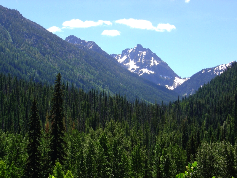
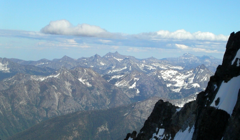
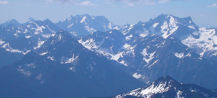
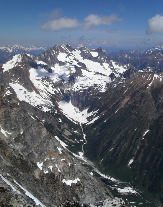
We parked at the Bridge Creek Trailhead (about a mile or two beyond Rainy Pass), crossed Hwy. 20, and started the long, dusty trek down the Pacific Crest Trail (PCT). It was 10am and we had about 10 miles of easy hiking on the PCT, downhill for the most part before reaching the Walker Park Trail junction (North Fork Bridge Creek). Scenes from those 10 miles of hiking weren't too terribly interesting but included numerous stream crossings (one over a suspension bridge near where Bridge Creek narrows to a canyon), touron sightings, and brief glimpses of distant peaks-Bowan Mountain (7,895 ft) at left about 5 miles in, and what was probably Spider Mountain directly ahead. We turned right onto the North Fork Bridge Creek Trail, and continued for about another 3 miles before stopping to filter some water at Grizzly Creek. We looked up-valley at hanging glaciers and intimidating rock faces partly obscured by clouds, towering high above timbered slopes (Mount Goode at left with Storm King Mountain at right). After a brief rest, we continued hiking for about another mile until we spotted a faint trail spur off to our left, heading into the brush (immediately after last stand of trees before large clearing).
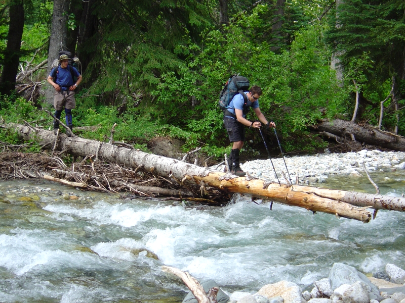
A short bushwhack brought us to the creek crossing. There weren't any signs of the alleged snow bridge spanning the creek. Instead, we located a sketchy log on which we could cross. Eric went first. It was my turn next. There was a crack in the log about 2/3rds of the way across, making for a very bouncy ride. It felt as if my stride was in harmonic oscillation with the bounce of the log. About halfway across, I lost my balance and instinctively dropped to my hands and knees. Needing my hands to grip the log, I automatically let go of my trekking poles and helplessly watched them float away. Hmm...should have used those wrist straps. I carefully crawled across the rest of the log to the safety of the shore. Tom also had difficulty crossing the log, but fortunately we all made it and remained dry.
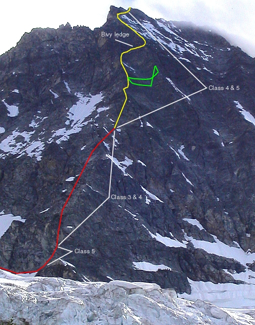
A short thrash through slide alder brought us to the edge of a large snow finger. Looking up, we could see the vegetated cliffs that protect the upper basin below the Goode Glacier (route follows the right edge of the left-most watercourse). Higher up, the Northeast Buttress comes into full view (ascent route marked in red and yellow w/ detour marked in green), it looked steep and intimidating. Thick clouds would come and go, occasionally obscuring the upper third of the buttress. We kicked steps up the snowfield to a broken class 3 - 4 buttress immediately right of the obvious waterfall. We climbed upwards on smooth slabs, with at least one extra spicy, exposed, class 4 move. Rap slings around small trees at these spots, assured us that we wouldn't have to reverse the moves on the way back down. Following the path of least resistance, we located an extremely faint "trail" that led up through alternatively slabby and brushy terrain just to the right of a watercourse. The "trail" eventually exited the last brushy alder patch and deposited us at the aforementioned watercourse. We easily hiked up either side of the watercourse to a grassy bank on the right side.
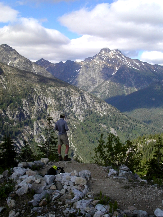
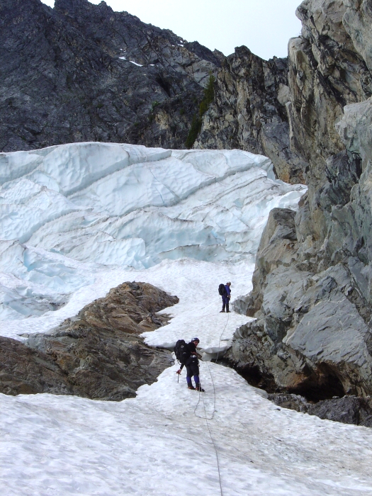
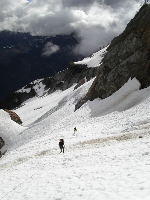
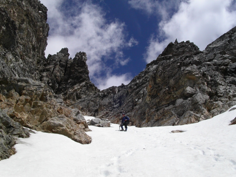
We continued up the bank to about the 5100 ft elevation, at which point we began looking for the bivy site that apparently accommodates four people. Looking at an adjacent bank to our right, Eric and I located a miniscule "bench" at what appears to be the highest stand of trees in the upper basin (views of Black Peak across valley). The bivy site turns out to be smaller than expected; a tight squeeze for three people. Eric and I claim our spots and wait for Tom who's clearly feeling the 14+ miles we'd traveled that day. We spent the remainder of the evening fighting off mosquitoes and throwing rocks at the curious marmots. Alarm clocks were set for 3:30am; we retire to our bivy sacks. Clear skies that night reassured us. 3:30am comes and goes. Nobody stirs. We wake up to low clouds and a light drizzle. Conditions weren't exactly motivating, but we decided to at least "check out the lower buttress". We left camp at 8:30am. Making a rising leftward traverse beneath cliffs, we climbed up a short snow and rock gully and exit onto the lower glacier slopes, directly below teetering seracs. We quickly traversed below these seracs, making for a prominent rock buttress at the far left end of the glacier. We gained the upper glacier by traversing below the buttress, and climbing immediately upwards on its left side to a small saddle. Avoiding crevasses as necessary, a boot path to the right lead us towards the Northeast Buttress. The drizzle had stopped and clouds looked to be breaking up. Spirits soared. Viewing the buttress from the side, I could see that the lower half wasn't nearly as steep as it appeared from camp ~ class 3 - 4 at worst. Nevertheless, I was skeptical about us making it to the summit and back before nightfall and privately wished I had packed my bivy gear along; a wish that would come to haunt me.
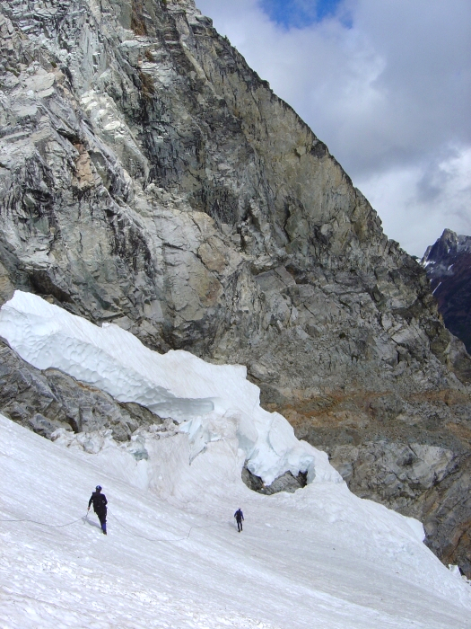
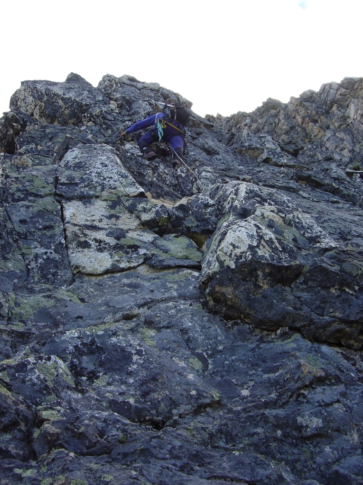
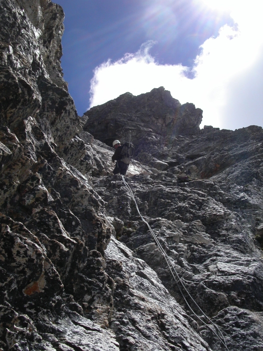
Crossing a sketchy snow bridge spanning a deep moat, we gained the lower buttress. We then simulclimbed a pitch of blocky 5th class rock to reach the buttress crest. After about 800 ft of heathery 3rd/4th class rock on the left (southeast) side of the buttress, we again encountered steeper rock. I reached a comfortable belay notch after free climbing a couple 5th class moves on a blocky face. Tom and Eric followed with a belay. While on belay, I climbed up onto the narrow arÄte of the Northeast Buttress, and followed it as it trended rightward before exiting onto the easier (mainly 4th class) rock on the right-side of the arÄte. I called to Tom and Eric, telling them to break down the belay and just simulclimb the pitch instead. We were making good progress until I opted to traverse right on thin ledges across a wide gully because the climbing on the right-side of the arÄte became more difficult (work left back towards arÄte instead). After an extremely sketchy traverse without pro, I reached the adjacent buttress and set up a lousy one-nut belay.
Once we were all "safely" at the belay, I again led out up the arÄte. A difficult vertical step complicated matters. I attempted to bypass the step on the right, but featureless slabs made this a scary proposition. My only option was to climb directly upwards. I managed to find a good crack for a cam beneath an overhang. After a couple nerve-racking 5.8/5.9ish moves, I was safely sitting atop the arÄte. The climbing above me looked like more of the same and I was certain that Tom and Eric would have great difficulty reaching my position. We were clearly off-route and needed to be back on the buttress to our left. Christ! Why do I always have to make things harder than they are? I located a horn in front of me from which I could rappel back down into the gully. I informed Tom and Eric of my intentions and pulled up one of the ropes. Opting not to retrieve my cam, I rapped an entire rope length (plus some stretch) back down to a ledge and traversed the gully back to the "real" Northeast Buttress. Tom and Eric traversed a higher ledge to where the rope was hanging and also rappelled back down. Standing back at the spot where I initially began my traverse across the gully, I looked up and now saw easy, blocky 4th class terrain that trended left towards the arÄte of the Northeast Buttress. We soloed about a pitch before stopping to set up another belay. I knew we were on route when I smelled, and then unknowingly stepped into a pile of human excrement.
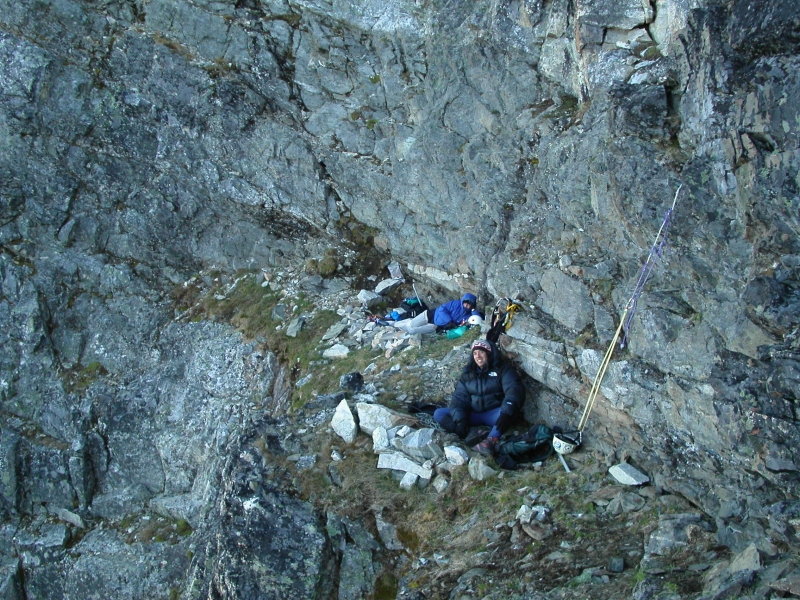
It was now a little after 4 pm. I turned to Eric and mentioned that we would be spending the night on the mountain. He looked at me in disbelief. We had easily lost an hour, if not two, by venturing off route. My objective now was to reach the 8000 ft "bivy ledge" that Paul Klenke informed me of via email a few days prior to our climb. He wrote: "At around 8,000 ft the buttress merges with a gully face and becomes indistinguishable. This gully face looks like a small amphitheater from below. Just above this amphitheater is a very large ledge. IF IT IS GETTING DARK OR YOU THINK YOU MAY BE BENIGHTED, STOP HERE. There are no suitable ledges for about 4 more pitches of climbing (note: we had a 60m rope). The big ledge will accommodate > 12." After two more pitches of low 5th class rock, on or near the arete, I reached the grassy ledge. The ledge really wasn't that big, and accommodates 3 or 4, but certainly not 12.
It was now 6pm. I suggested staying put and calling it a night. We could probably reach the summit before dark, but would find little in the way of shelter from the cold and wind at the summit bivy sites. We piled on whatever clothes we had and prepared for the inevitable shiver-fest (thank God for my down jacket). The ledge offered sweeping eastern views and would fortunately receive the first rays of light the next morning. Resting on a rope-mattress, Tom pulled his pack up over his legs. Eric, on the other hand, curled up into a noisy garbage sack. My pack, being barely large enough for a boot, let alone two boots and a pair of legs, would only serve as a pillow. I started out that evening attempting to sleep at the far right end of the ledge. It didn't take very long for me to abandon my self-imposed isolation and seek out a "warm" spot between Tom and Eric. We could see my bright yellow bivy sack glowing in the fading twilight about 4000 ft below...mocking us. The temperature continued to drop...
Well, we all got very close to each other that night, literally. Spooning--the term now takes on an entirely new and most unappealing meaning for me. When someone had to roll over, we all had to roll over. Eric was stuck blocking the wind. My legs, curled up in fetal position, cramped all night long. Tom was just plain freezing his ass off. I may have gotten an hour worth of sleep that night, probably less. Then someone uttered "it's 3:30am", or something. Finally! We sat there, watching the orange glow of sunrise creep from beyond the horizon. The first rays soon cleared distant peaks and pierced across the sky like laser beams. Before we new it, we found ourselves uncomfortably warm, peeling layers of clothing back off. After a delicious GU breakfast, we traversed the ledge to a parallel buttress and set up a belay. It was a little after 6 am.
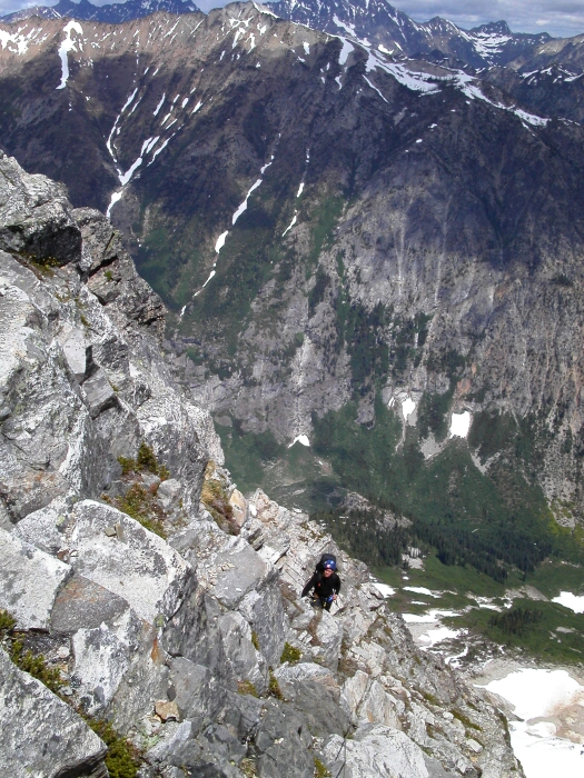
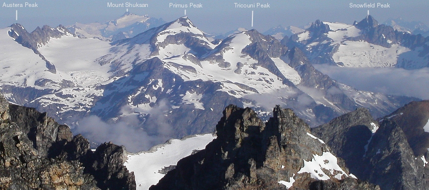
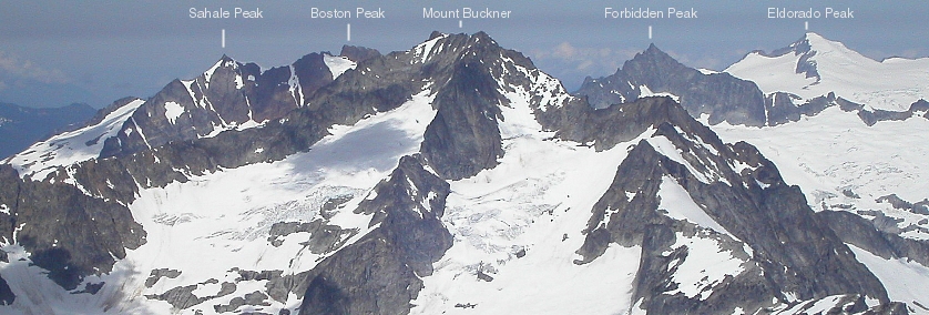
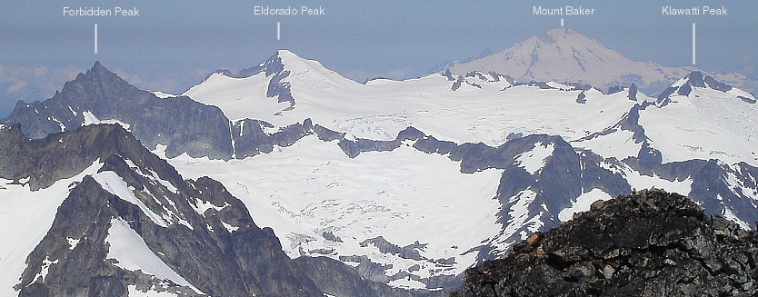
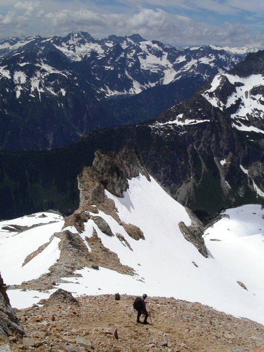
From the ledge, I led two very enjoyable pitches up blocky 4th - low 5th class rock. Eric then elected to lead the next pitch, and cut back to the arÄte to avoid steep snow on the face. He followed the arÄte (Black Tooth Notch below at left) to an obvious rappel anchor and set up a belay. Back on lead, I continued upwards and traversed right across gullies and loose blocks to the final impediment-a tall slabby block that some have apparently used an aid piece as a foot loop to get up over. Around a small corner to the right, however, I found an easier way up and set up a top belay at the next set of rappel slings. After another 50 ft of mostly 3rd class choss, we reached the summit. It was now 10am, and the adventure was still a very long way from being over. We took a few minutes to savor the fruits of our efforts and enjoy the spectacular views!
What goes up must come down. We certainly were not the exception. Two sketchy, angling, pendulum rappels brought us to ledges that lead to the Black Tooth Notch (beginning of the crappy Southwest Couloir). I found the 2nd rappel particularly thought provoking, and had to hook a horn (ratty slings) with the rope so as not to pendulum over a cliff. Inevitably, the rope snagged when Tom tried to pull it. Eric and I were happy not to be tasked with trying to free the rope from that small, super exposed ledge. Three more rappels down the Southwest Couloir brought us to a 35+ degree snowfield. We carefully plunge-stepped and reverse front-pointed our way down the slick snow until reaching yet more choss. Working left to avoid a cliffy waterfall, we continued the descent on crumbly rock and scree until reaching open snow slopes below the SW couloir.
We traversed below the impressive West Face of Mt. Goode, rounded a buttress and continued traversing a snowy bench (initially quite steep) before angling upwards on heather, then snow, towards the Goode - Storm King Col. Another sketchy rappel and we were safely back on the Goode Glacier. More steep plunge-stepping above a wide bergschrund (bypassed on the left), brought us to the gentle slopes of the upper glacier. Eric led back right, to avoid the fractured glacier on our left. We descended the right-side of the glacier, avoiding crevasses as necessary, all the way down to heather meadows. Traversing right, below slabs and above a waterfall, we easily negotiated the route back to camp. It was 4:20pm when we arrived.
We left out little for the marmots to destroy, yet I was surprised to see that they had managed to pull my empty freeze-dried dinner pouch out from underneath a boulder, and chew it to shreds. Little bastards! We hastily packed up camp and began our descent at 5pm. We made one rappel down the most difficult section of slab, crossed the creek (this time without incident), and reached the trail by 6pm. An unimaginably long 14 miles of trail were all that now stood between us and the car. Eric took off at a blistering pace. I managed to keep up with him for about a minute. Tom and I wouldn't see Eric again until we reached the car many grueling hours later. Hot spots turned to blisters and the boot camp death march turned into a multi-mile aching hobble. I lost Tom for a 3 or 4 mile stretch of trail, during which time I had a bizarre encounter with a charging wolverine (that was no damn marmot!). I jumped out of the way at the last minute, after considering giving it a good kick in the face.
The last 2 to 3 miles were filled with the usual anticipation of the trailhead being just around the corner. Tom and I expected to reach the car by 10pm, maybe 10:30pm at the very latest. 11pm came and went and there still was no sign of the trailhead or road for that matter. Eventually, we heard traffic, and, what felt like an eternity later, we saw the lights. Still, the trail dragged on (it parallels the road). Tom and I finally crossed over the highway and woke up Eric, sleeping soundly in his car. It was 11:20pm and I was thoroughly wasted. I swore to myself that I would take a long break from climbing after this trip. Alas, the soreness subsided after a day and my blisters healed quickly. Somehow, I convinced myself to climb Mt. Thomson that very next weekend. So much for taking a break!
Click here to view photos.
![]()


