


Snowfield Peak - Neve Glacier, December 2002 (by Paul Klenke)

Here we go again: another Indian summer climb of a major peak in the Washington Cascades. I'd like to say this excellent autumn weather is getting old. When will it start raining on a consistent basis so we don't have to hear local "authorities" fretting about drought possibilities for next summer? To quote from that Blues Traveler Mr. Popper, "But Anyway"... Sergio and I left Kirkland around 6:45AM after practicing our car shunting procedures in his apartment complex. Let's see: red Honda here, white Volkswagen there, red Toyota here. Oh, and don't forget to pop the parking brake! We made the usual food stop at Tom Sjolseth's favorite grocer--the Arlington Food Pavilion--before proceeding on our way to the trailhead. We forgot (or did we neglect?) to stop at the park service office in Marblemount to pick up a permit. Who's going to be up there but us? (Note: we didn't see anyone else for the whole climb.)
As is wont for Sergio, he was speeding his way along the North Cascades Highway when the trailhead suddenly appeared at a blind bend in the road. "Oh, here it is," I announced and so Sergio yanks the wheel over and cruises into the wide gravel strip that is the parking area across the road from the Pyramid Lake Trail (1,100 ft). So as to not lock up the brakes on the loose gravel, Sergio comes to a slow stop at the upper end of the strip-the farthest possible distance away from the beginning of the trail (about 120 yards). While he was slowing down, I was thinking he would throw the wheel over and backtrack to the opposite end of the strip so as to park directly opposite the beginning of the trail. I based this thought on experiences riding with him to Dome Peak, Vesper Peak, and Jack Mountain. On all of these, he had parked as close to--if not on top of--the worn path that fans out from the trailhead. But this was not the case this time, and this would come back to annoy us later (but I don't want to get ahead of myself).
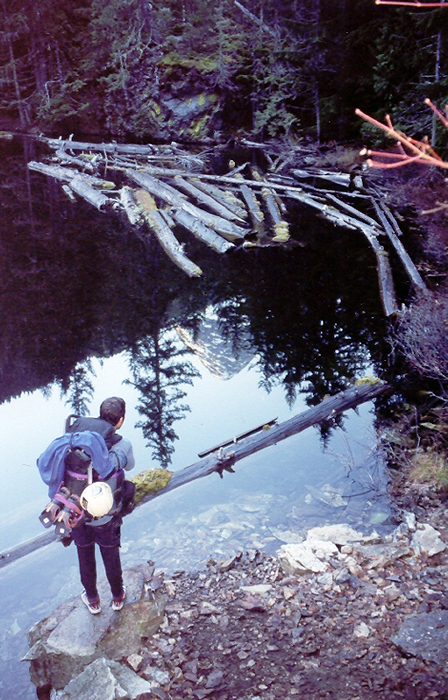
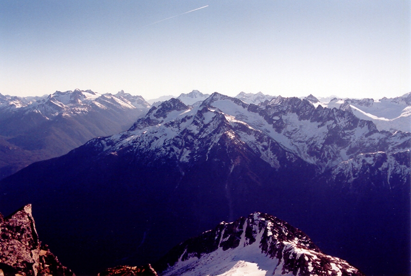
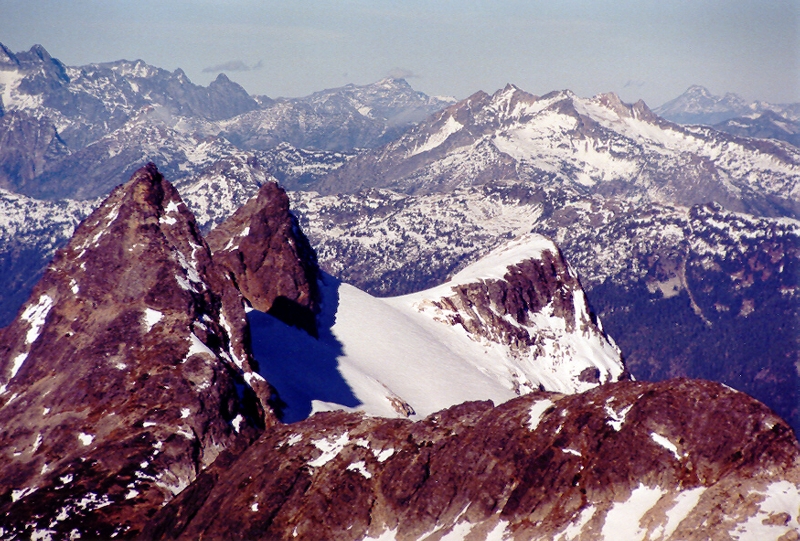
We left the car at 10:00AM. By about 11:00AM we were at diminutive Pyramid Lake (2,640 ft). The trail to the lake is in good condition. We only "lost" it temporarily at the creek crossing in the flat timbered area about halfway to the lake. The lake itself isn't very picturesque unless you walk along its northeastern edge (below the rocks at left) to a point where Pyramid Peak can bee seen both above and in reflection to the southwest. I had been up to the ridge above the lake before in June 2001 in a failed attempt at Snowfield Peak. Actually, in that trip, we were snowed on 6+ inches at camp, so we bailed on the climb without going any farther than that. I remembered the climb up to camp being a grunt on that trip and I relayed this to Sergio. Yep, it was a grunt this time too--an exercise in slimnastics. The steep trail is fairly easy to follow in daylight as it winds its way up alternately cliffy, forested, and under-forested slopes. At around 4,300 ft, the trail finally climbs out of the trees and the first expansive views are offered: from the Pickets to the northwest all the way around to a conical Gabriel Peak to the southeast.
The trail then continues via several possible paths over the flat stunt-timbered ridge top as it navigates past ponds here and there. These ponds (the largest about the size of a tennis court) were all iced over, but not so much that we could walk over them without crashing through. Past the ponds, the trail more or less disappears at a bouldery apron below a rock wall. The trail goes right up a timbered break in the middle of the rock wall (and I knew this), but nonetheless we did not find it and instead bushwhacked that 100 vertical feet to once again find the trail at the geodetic marker that signifies Pt. 4555. We took a break here and spied distant peaks and the nearby steepening ridge ahead of us. We left Pt. 4555 at 1:20PM (3 hours, 20 minutes from the car) and stayed on trail for the next 30 minutes or so. The trail first goes along the ridge top on the other (southwest) side of Pt. 4555, then goes around the right (north side) of the next craggy hump. Here, bright pink tagging helped us keep on trail. Beyond this hump, the ridge steepens quite a bit (this is the steep part you can see from farther back down the ridge). The trail essentially goes right up this steep, cramped slope for the first half then contours over on the right (north) side for the second half. At the tail end of this latter half, the trail all but disappears in a short section that traverses an extremely slippery duff slope. Fortunately, green belays offered their assistance.
Beyond this, the trail can be found again in the flat area that comes next. This flat area was snow-covered. The trail then angles up just left of the crest until tall cliffs ahead and below force you up and to the right. We followed the trail upward until permanent snow finally obscured it completely. But by that time we knew where we were. Timberline had given way to alpine. We were now at the first rocky high point where I camped in 2001 (5,400 ft). We dropped our packs to see if the cairns we were seeing actually were the way we wanted to go. The cairns seemed to go down a ledge that led to an ugly south-facing gully that drops down into the Colonial Creek basin. It was a possible way to continue on the next morning, but I wasn't convinced. So, while Sergio set up camp at 5,600 ft, I went on a little scouting mission up to the top of the 5,840+ ft high point on the ridge to see if there was an easier way farther up. There was.
So, here we are. It's dark; and it's only 5:00PM. Climbing in late November is so much more different than summer. It gets dark so early. It seemed like we had an eternity to wait until morning. The whiskey went down after dinner. We were buzzing, I think. Or maybe we were just acting stupid because that's normal for us. There was a strange flashing of the caliginous sky (like a strobe but not consistent in its occurrence) coming from the horizon to the southeast (in the direction of Gabriel Peak). It was many miles away. I conjectured that it might be an airport beacon in the Methow Valley. But now, looking at my map, I realize that the flashing was coming from the Stehekin direction. Sergio thought the flashing might be fireworks going off on some indian reservation. Hmmm? Conclusion: it was a UFO (an unidentified flashing object).
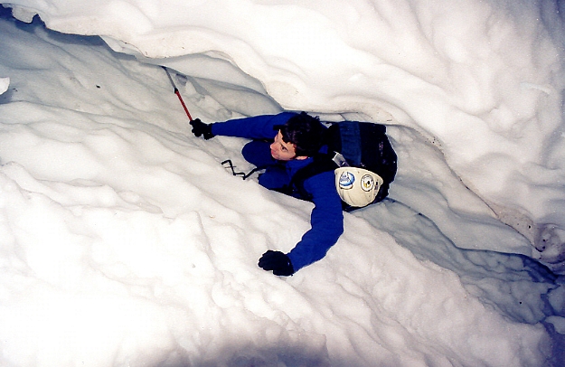
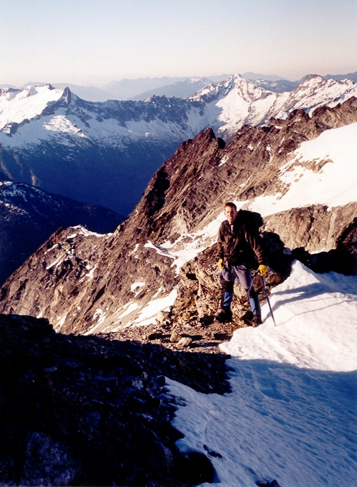
The next morning, after slimsy sleep for myself and sleek sleep for Sergio, we headed out with crampons on at 6:45AM. It was not yet light but not so dark that we needed headlamps on the snowy terrain. The snow was mostly firm but, because it was only 32 degrees, there was still some undesired plunging-through going on. From the gentle saddle west of Pt. 5840+, we needed to contour over to the "liquid" waterfall spilling out of the upper Colonial basin. Sergio was traversing as high as possible and I was following. There was a flatter way to go lower down, but it meant a little elevation loss. All was going well until Sergio dropped his trekking pole. He watched it slowly slide down the snow slope until it dropped into a crevasse-like crack in the snow. How convenient that that crack was there, else his pole might have gone 1,000 ft down into the basin. Sergio looked silly climbing down into that crack to retrieve an errant pole. Sergio: two words for you: wrist straps. Sergio's other little error was leaving his camera in the tent. Fortunately, I had mine so we would switch off taking photos with it throughout the day.
There is a flat area above the waterfall that would make for a good camp if it is not windy. There is a water source in the stream right above the waterfall. When we were there, there was a chilly katabatic breeze blowing out of the Colonial Glacier basin. Not very pleasant. Between the waterfall and the glacier, there is a large tarn (frozen over for us) that has obviously formed upon glacial retreat. The glacier itself had no crevasses in its flat lower section and only a few on its upper section. Mostly, it was just a case of bare ice showing. The few crevasses we saw were easily avoided on their left as we made our way to the 6,840+ ft Colonial-Neve Col. We were at this col in 1 hour and 45 minutes--a pretty good rate of travel, I thought, even with both of my crampons coming lose on me. In fact, I climbed the last 200 vertical feet of glacier on 20-degree slopes balancing on my crampons. I had to go straight up the snow so as to not twist my boots off the crampon platforms. Once at the col, I fixed (and tightened) my crampons. They would not hamper me again.
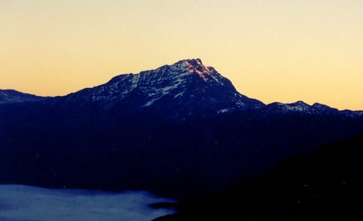
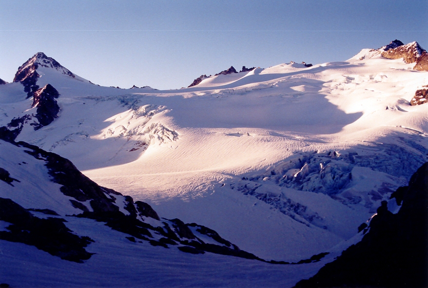
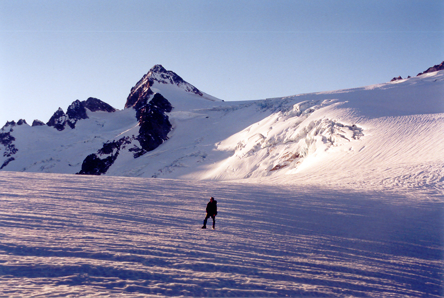
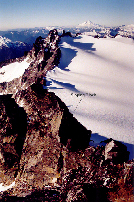
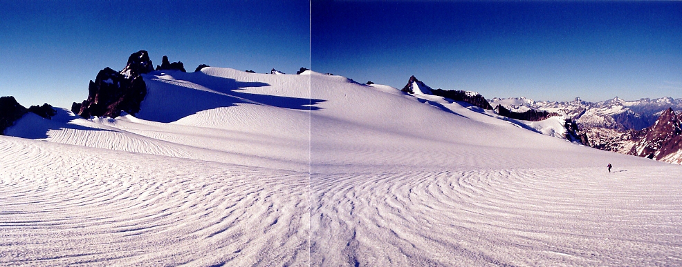
The Colonial-Neve Col is the first place from which one can view Snowfield Peak. Up to this point, we had no idea what the Neve Glacier would be like. Was it going to be so severely broken up as to prevent navigation through it? As it turns out, there was a wide highway right up the center between flanking crevasse fields. The glacier looked like it might in August. Woohoo! The next worry was this supposed exposed notch near the summit. But that worry will have to wait. We'll cross that notch when we get to it. It was a joyous climb down onto the Neve Glacier. Spirits were high. No climbers should be so deserving of such conditions in December. It is an interesting glacier in that it drains both to the west into Ladder Creek and to the east into Neve Creek. There is another interesting yet uninspiring thing about the glacier: it goes on forever--especially on the upper portion beyond the one section involving minimal crevasse navigation. Once we stepped across a couple partially collapsed but completely stable snow bridges at ~7,200 ft, we found ourselves on the upper neve. The long West Ridge of Snowfield seemed so close then. In ten minutes we would be at this craggy ridge. No problem.
Thirty minutes later, we finally got to the craggy ridge! We made ridge-fall at the 7,900-ft level left of the most severe crags--essentially at the base of the west ridge/slope of Snowfield Peak. From there, the summit looked like a piece of cake. Notch? What notch? And it was only 10:00AM. The south side of the ridge was completely snow-free. Can this really be December? Stopping there, we ate like kings. Sergio had some bread and a can of albacore. He was so stuffed by it that he even offered me a few bites. What a guy! For some reason, he wasn't interested in part of my peanut butter sandwich. Maybe it was because I had already eaten it.
Don't you hate it when you're climbing well in 5th gear and then you stop for a break and when you start up again your stamina has notched back to 1st or 2nd gear? (Notch; did I use the word notch again?) Well, this was what happened to us. Going up that benign, partially grassy slope was a groaner, even if it was only 200 vertical feet. The slope ended at a rocky area with a cliff on the other (east) side. From a crenellation in the rocks, we could see the summit up above across a chasm. Seemed simple enough: just climb the rocky ridge around to the left. So, we roped up with our 30m rope and brought out all the other necessary rock climbing gear. I had brought along a small rack (9 cams and 4 passives). Sergio offered to let me lead out perhaps as conciliation for him having done all the leading on Vesper Peak back in September.
I initially scrambled up the rocky ridge in front of us but I retreated when it looked like the ridge might cliff out ahead. This was a good move, as this part of the ridge was actually a gendarme. The deep gully to the left looked feasible, so this was my next option. With Sergio providing an ad hoc belay, I traversed and then descended a few icy boulder steps into the 20-foot wide gully. I took along my ice axe in case I needed it. Fortunately, the snow in the gully was soft enough to make good steps in. I set a few pieces climbing up the 50 feet of mixed snow and rock in the gully. I approached a very prominent notch where the aforementioned gendarme ended in a vertical drop on the right. There was a rappel sling there. From near the top of the gully, I climbed up onto the rocks of the rib left of the gully. At about this time, our 30m rope had paid itself out, so I waited for Sergio to climb down into the gully before proceeding up the rock wall left of the notch. We did a running belay for the next hundred feet or so. The rock wall narrowed considerably to a knife-edge. Is this the West Ridge alternate finish Beckey speaks of? It's definitely not class 3; is mostly class 4; and contains one class 5 block.
Stashing my ice axe, I ran out this knife-edge protecting it as I went. I climbed forward on good rock until I came to a slight problem. The terminus of the sharp ridge is comprised of an unprotectable block about the size of a backyard aluminum shed, the top of which is probably just as slippery/airy as the roof of said shed. To continue on, it would be necessary to jump down off the sloping block to a boulder below in the last notch before the final summit scramble. Depending on how and where you jump from the block, this dyno descent can be as short as 3 feet or long as 10 feet.
The block sloped off to the left at a shallow yet steep enough angle that if you slipped you probably wouldn't catch yourself before going over the edge. I was 20 feet past my last pro placement--a good cam in a good crack--when I proceeded to sidle down the sloping terminus of the block until I could manage to get my left foot on a fortuitous feature. With my right hand using the edge of the block for a pseudo-layback, the rest of my body followed my outstretched left leg until I was using the feature as a hold for my left foot and left hand simultaneously. I sat down on the edge of the block not feeling all that comfortable. The boulder I needed to jump to was right below me now, but I couldn't jump until I knew there was enough slack in the rope (maybe six feet would do). Meanwhile, Sergio is behind me out of sight. I yell out to him to give me some slack, which he does eventually. I then lowered myself off the block slowly until friction could no longer hold me. When I felt my body going, I let go and leapt down to the rock. Great gold-medal landing! If this were an Olympic sport--
I crossed the easy notch (yep, crossing this notch was easy; getting into it was what was hard) and climbed up the blocky wall on the other side. There, I set another small cam in one of many possible cracks then climbed up and right to a grassy ledge. At about this time, Sergio came up into view at the beginning of the knife-edge traverse. He expressed his pleasure (displeasure?) at the aesthetic sight of it. Next to where I was standing was a rappel sling to which I clipped into. When Sergio arrived at the big sloping block I told him what he had to do. He didn't seem too enthused at first. I put him on belay (not that it would make much difference for his possible pendulum fall) at the rappel sling. I had a front row seat to watch Sergio do a stretch dance on top of the block. Well I'll be; his dance was completely different from mine. Where's his left foot going? You can't do that from there! Fool, fool! Actually, he was fine with what he was doing. It just looked awkward from my point of view. His landing was only good enough for the silver medal though.
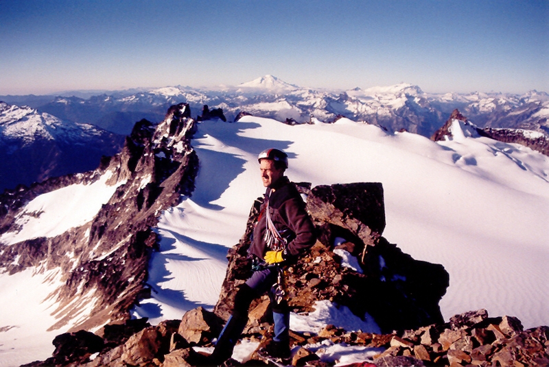
After that, the summit was reached easily (class 3 scrambling at most). There wasn't much snow on the route. It was maybe 40 degrees at the summit. The only place that had unavoidable snow was in the recessed gully. We signed the register (the last successful ascent was some time in October) and took the obligatory summit photos. A few peaks were acquiring mid-level clouds on their summit flanks, but no such rotten luck on our peak. Sergio wanted to get back to the car that night, so we knew we'd have to boogie. All we needed to do was get to Pyramid Lake before dark and we were set.
On the return, we opted not to go back via the block and knife-edge ridge and instead go down the south-facing gully/chimney that descends from the last notch before the summit (where the dyno jump was located). The plan was to descend the gully forty feet or so until another short, rocky, class 3 chimney allowed access back up to the sharp notch at the top of the aforementioned snowy gully we climbed up. And this is what we did. Descending the gully/chimney was interesting in that it was totally an off-balance thing with a steep, sloping slab on your left and a slightly overhung wall on your right. Again, Sergio's form was completely different, though just as satisfactory, as mine. The other thing about that chimney was that it was hotter than hell in there. It must have been 20 degrees warmer in there than the temperature at the summit as if the rocks were focusing the sun's heat into it.
While I climbed back up to retrieve my ice axe that I had left at the beginning of the knife-edge traverse, Sergio set up a rappel at the top of the snow-filled gully. And while Sergio rappelled the gully, I climbed down it right next to him--the rope twanging against my helmet as I descended. Not your most useful rappel, for I made it to his position as he was unclipping from the rope. By 12:40PM we were back at the base of the West Ridge. I applied duct tape to my too-far-gone Achilles heels and then we were off. Even on the downhill, the upper Neve Glacier seemed to take forever to dispatch. Then there was the 200 feet of climbing to get back up to the Colonial-Neve Col in the full on bore of sunshine. Sweat city! Our thought was that, if we get back to the tent by 2:30PM and then leave by 3:00PM, we should have enough time to get back to the lake by deep gloaming. I did not relish the idea of coming down the thin, windy trail above the lake in total darkness (even with headlamps ablaze). It didn't help that the descent would be on the darker north side of the ridge.
At the Colonial Glacier tarn's outlet stream, we replenished our water supplies then carried on without incident back to the tent. We were fifteen minutes behind schedule. We broke camp at light speed, but it still took half-an-hour. All movements and actions were efficient, so Sergio just couldn't see how we could have done it faster. We hardly spoke to each other so as to not break each other's concentration. Only one goof up occurred: Sergio laid a long half-deployed (half-unbent) tent pole before me to deal with. But when he laid it down, the one or two bent sections deployed themselves and this caused the whole pole to launch itself along and down the snow slope. Before I could turn around, it had already zoomed 10 feet. Fortunately, a small rock outcrop barely stopped it; else it too (like Sergio's trekking pole) would have gone a long way down the mountain.
We left our campsite at 3:15PM. We had perhaps one hour and forty-five minutes of daylight left. We actually made good time getting back to where the trail finally leaves the ridge. Only a few short sections of bushwhacking were necessary when we would temporarily lose the trail in our haste. Below the ridge, Sergio took off like a rocket. But I would go no faster than my aching feet would allow. They were the bosses of this transport now. I was simply a willing passenger. Sergio got so far ahead that he couldn't hear my calls. In the dark trees, the trail became more and more obscure as the light faded away. I had no desire to find myself ensnared in a chaparral even a headlamp couldn't penetrate. I temporarily lost the trail once about midway down to the lake then lost it again where it crosses a small boulderfield just above the lake (Sergio also lost the trail here). At this point, I could hear Sergio calling, see his headlamp shining far below, and see the bible black void that is the lake. I found what must have been another lake-viewing trail and shortly found myself at water's edge. It was 5:10PM. We had made it! And no use of headlamps up to this point either!
From the lake to the car, it was one hour more of pain and misery for the blains on my toes and blisters on my heels. We tried to talk about distractive subjects, but the aching always seemed to finish every paragraph of conversation. Eventually, we could see the distant lights of the Diablo Dam and town site. Still further and we could hear cars going by on the road. Still further and we could see the cars. We were there, finally at the road again at just after 6:00PM. We had dropped 7,200 feet in six hours. That may not seem like much, but we had gone a long way in one day [(3 basins + 2 cols) x 2 / 1 day]. And yet, we were not done. Why in the hell did Sergio have to park so far away from the trailhead!
Click here to view photos.
![]()


