


Bryan Butte - Southeast Route via Summer Blossom Trail, December 2002

Bent on summiting his last remaining peak of the "top 100" in the Chelan/Sawtooth region, Paul proposed that we go climb Mount Bigelow. Though not necessarily a "top 100" disciple myself, I was somewhat interested in a trip to Mount Bigelow purely because I had never been in that remote corner of the Cascades. What also factored into my decision to go was the additional promise of seeing an actual rock glacier formation, and the nearby Hoodoo Peak, Star Peak and Oval Peak; which I heard Tom Sjolseth make frequent reference to this summer.
We estimated that it would take us somewhere in the neighborhood of three-and-a-half hours to make the drive out to Winthrop. The driving time, the 5 or 6 miles of hiking to reach the summit, and the limited daylight hours all necessitated an early start from home. It was Paul's turn to drive and in no time we found ourselves cruising down the North Cascades Highway towards Marblemount. It was also around this time that I made the unpleasant discovery that I wouldn't be able to enjoy the basic civilized comfort of heat in Paul's car. Paul dismissed the artic temperatures in his ice-box of a car while I wrapped myself in a blanket and donned my down jacket. The excitement was however far from over as we got pulled over for speeding just outside Winthrop, ironically only seconds after Paul mentioned how well patrolled this particular stretch of road was. Paul informed the officer that his speeding was a consequence of his desperate need to urinate (a lie), for which we were then given the grand escort by Winthrop's finest to a public restroom in town. Returning from the restroom, Paul then had to endure a detailed lecture and barrage of statistics from the officer concerning various speeding related accidents and fatal encounters with wildlife. We were then released with only a warning and continued on our way.
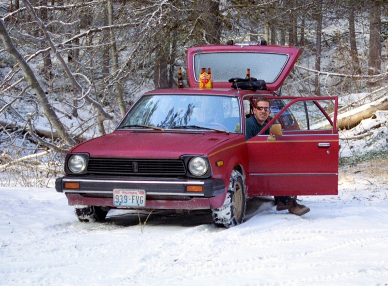
About five miles past Carlton, we turned right onto Gold Creek Road. It wasn't long before we encountered snow and hoped that we'd be able to at least reach the trailhead by car. We continued up the logging road expecting to reach the trailhead after each successive bend. Our altimeters were also reporting an elevation higher than that of the trailhead, and the road only continued climbing. I was beginning to suspect that we had made a wrong turn somewhere. The increasingly unconsolidated snow was also beginning to make driving difficult, and soon the tires were spinning out and we could go no farther. To make matters worse, in an attempt to reverse the car back down the road to a bit of a pull-out, Paul managed to get a wheel stuck in a shallow ditch. Any summit bid of Mount Bigelow was now out of the question and Paul and I struggled for another half hour to push the car free. Fortunately, Paul had brought his snow chains with him and was able to drive out of the ditch after having put them on. Now, with the added traction of the chains we continued up the road, hopeful that we were somehow near the trailhead. We finally reached a junction with signs on a ridge-top and discovered that we were in fact way off route. My suspicions confirmed, I reached back and opened my first beer for the day.
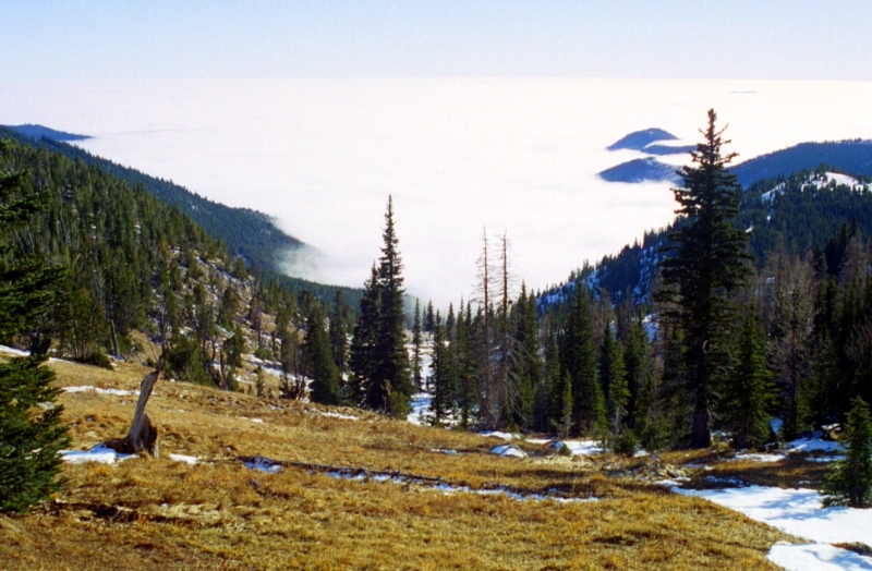
Ok, so now that Mount Bigelow is out of the question, what do we do? After a brief review of Paul's Washington Atlas and Gazetteer, we determined that North and South Navarre Peaks were sufficiently close to offer a feasible backup summit. We spied what we thought were the two peaks from the road and continued for a short distance before stopping at a pull-out. Confident that we'd be able to easily run up to the summit, Paul and I laughed off our previous navigational issues. We stuffed the remaining beers in our packs and set off in anticipation of enjoying some nice summit beers on top of North Navarre Peak. We trudged through forest and followed a small creek as it led us upwards through patchy snow towards open terrain. In what felt like an eternity we reached an open meadow in the upper basin. Looking back, we could look over Eastern Washington under a sea of fog. Paul and I jokingly envisioned this sea of fog as being a glacial ice-sheet much like what must have existed thousands of years ago.
We continued up the basin towards a broad saddle. The craggy summit of North and South Navarre Peaks were nowhere to be found. Instead, on our left was this uninspiring hump of snow and trees. We post-holed our way up the hump onto the summit. Stunted pines covered most of the summit area, save for some rocky outcroppings near the craggy north side of the summit. Looking west we spotted Bonanza Peak rising prominently from the horizon (high peak left of center in background). We also finally located North Navarre Peak and South Navarre Peak, situated directly west of us and joined to the hump on which we were standing via a craggy ridge. We speculated as to whether or not our summit (just shy of 8,000') had a name and until a determination was made, we decided to call it "Plan C Peak". We also named our ascent route the "Endless Basin".
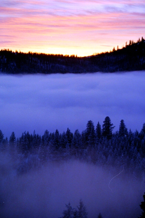
After a quick beer and late lunch on the summit, we returned back down to the saddle in the meadows. This time, we stayed to the left in the upper basin and did a descending traverse high above the creek until spotting the road far below. We then descended back down through forest and reached the car without incident. The sun was now setting and the fog was again creeping up the valley. Soon we too were deep in the fog and several minutes later found ourselves heading back towards Winthrop. We stopped in town for ribs and Paul experimented with an exotic spiced beer called Gruit Ale that smelled and tasted strongly of rosemary and apparently had some other narcotic herbs in it. By 7:00pm we were back on the road again for the three-and-a-half hour drive back home. That was about as much punting as we could tolerate for one day. Click here to view photos.
![]()


