Last Updated: November 19, 2024


Start

Recent content updates are viewable under what's new.

Reports in the queue for posting are coming soon!

Upcoming reports & photos:

Oh my! Quite the backlog here...

  • Mount Killam (Gambier Island) - hike (September 2023)
  • Lone Goat & Snow Camp Mountain - hike (September 2023)
  • Isollilock Peak - scramble (October 2023)
  • Mount Manson - Mount Hatfield Traverse - scramble (October 2023)
  • The Gargoyles & Columnar Peak - scramble (October 2023)
  • Opal Cone and Lava Glacier - hike (October 2023)
  • Park Butte (WA) - hike (October 2023)
  • Trappers Peak (WA) - scramble (October 2023)
  • Rattlesnake Ledge (WA) - hike (November 2023)
  • Sauk Mountain (WA) - hike (November 2023)
  • Sunshine Coast (Mount Daniel, Pender Hill) - hike (November 2023)
  • Mount Dickerman (WA) - hike (November 2022)
  • Verona Peak AKA Winter's End - snowshoe (November 2023)
  • Dolomites (IT) - snowboard (December 2023)
  • Red Rock Canyon (NV) - scramble (January 2024)
  • Flute Summit & Oboe Summit - snowboard (February 2024)
  • Whistler Miscellaneous (Train Wreck, Loggers Lake, Shadow Lake and more) - hike (February 2024)
  • Mount Underhill - hike (March 2024)
  • Bombtram Mountain - snowshoe (March 2024)
  • Steep Peak - snowboard (March 2024)
  • Ruby Mountain (WA) - snowshoe (April 2024)
  • Blustry Mountain - hike (April 2024)
  • Sowerby Peak (Barr East) - snowshoe (April 2024)
  • Picacho Peak (AZ) - hike (April 2024)
  • Kitt Peak Observatory (AZ) - (April 2024)
  • Mount Wrightson (AZ) - hike (April 2024)
  • Saguaro National Park (AZ) - April 2024)
  • Superstition Peak/Benchmark (AZ) - scramble (April 2024)
  • Mount Humphreys (AZ) - hike (May 2024)
  • Petrified Forest National Park (AZ) - (May 2024)
  • Piestewa Peak (AZ) - hike (May 2024)
  • Channeled Scablands (WA | Columbia Gorge, Ancient Lakes, Potholes Lake, Palouse Falls and more) - hike (May 2024)
  • Rhododendron Mountain ("Pk. 2220") - snowshoe (June 2024)
  • Flora Peak - hike (June 2024)
  • Gibson Peak - snowshoe (June 2024)
  • Mount Urquhart - scramble (June 2024)
  • Rock Mountain (WA) - hike (July 2024)
  • Ladies Pass Quartet (WA | Cape Horn, Ladies Peak, Snowgrass NE Peak, Snowgrass Mountain) - scramble (July 2024)
  • Old Snowy (WA) - scramble (July 2024)
  • Dog Mountain (WA) - hike (July 2024)
  • Mount Ratney & Mount Bardean - scramble (July 2024)
  • Torrent Peak - scramble (July 2024)
  • Steep Peak - Darkside Peak Traverse - scramble (July 2024)
  • Silvertip Mountain - scramble (July 2024)
  • The Old Settler - scramble (July 2024)
  • Silent Hub Peak - scramble (August 2024)
  • Saint Jacobs Mountain - scramble (August 2024)
  • Mount David (WA) - scramble (August 2024)
  • Goat Mountain West Peak & Table Mountain (WA) - hike (August 2024)
  • Griswold Pass (Tuber Hill, Glacier View Peak, Subatomic Peaks: Baryon, Meson, Muon, Lepton) - scramble (September 2024)
  • Yellow Aster Butte (WA) - hike (September 2024)
  • Mazama Dome (WA) - hike (September 2024)
  • Ptarmigan Ridge - (WA | The Portals East Peak, Coleman Pinnacle) - hike (September 2024)
  • Tetrahedron Peak - scramble (September 2024)
  • Lone Cone & Peak 86 (Tofino) - hike (September 2024)
  • Mount Athelstan ("Pk. 2460") - scramble (September 2024)
  • Excelsior Peak and Cowap Peak - hike (October 2024)
  • Hollyburn Peak - hike (October 2024)
  • Cheam Peak - hike (October 2024)
  • Blanchard Needle - scramble (October 2024)
  • Debeck's Hill & 4 Lakes Loop - hike (October 2024)
  • Mount Hallowell - hike (November 2024)

*As of 11/19/2024


Database

Query the reports database, selecting from criteria which include name, location, type, season etc.

Quick Links

Essential links & whatnot:


Jump To

Select from list below to jump to a specific area on this site.


| Featured Trip Report |


Last Updated: July 10, 2005

Mount Maude - North Face, June 2005
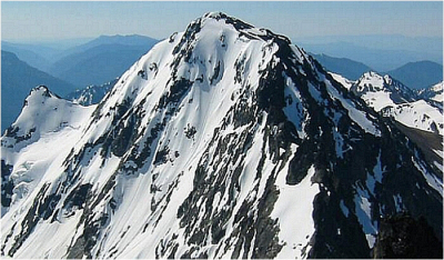


Wow, it's been a long time since I posted something new here, and by the soreness in my thighs it's obviously been a long time since I've climbed a mountain. This Spring has been good for little more than reliably soggy weekends and the over-consumption of beer. Add to that, weddings, surgery (not mine), low motivation, and just like that the few weekend days of acceptable climbing weather we've had this spring, simply passed me by. Occasional cragging trips (Leavenworth and Mt. Eerie) helped satisfy the itch somewhat, but, with the backcountry touring season at a premature end this year, at least as far as I was concerned, I reluctantly traded in my skis for crampons. It would be about a month before those crampons actually touched snow... On June 19, along with an all-star cast consisting of Andy Ball, Andy Johnson and Eric Hoffman, a much-anticipated climb of Maude's North Face finally came to fruition.

Leaving our trailhead bivy around 6:00am, we made good time hiking the flat Phelps Creek Trail. We crossed Leroy Creek in about 3 miles and turned uphill for the steep grind to Leroy Creek Basin, reaching the campsites in about 2 hours. We followed the trail (Carne Mountain High Route) as it traverses right beneath cliff bands in the upper basin. We left the trail after a small stream crossing and booted up a steep heather slope to reach the bench above. We donned our crampons just above this bench and continued up on firm snow to reach the Seven Fingered Jack - Mount Maude Col.

After a short break, we roped up (2 parties of 2) and began the short (100'), but steep descent onto the snowy bench the marks the beginning of tedious traverse towards Maude's North Face. In the early season conditions we encountered, the traverse can best be characterized as a royal pain in the ass. Endless wallowing in loose, wet snow, and much face-in down climbing eventually saw us atop a final steep (60-degree?) snow descent beneath a rock overhang. In total, we had lost about 400 feet from our high point at the col.

Now finally on the North Face, Andy B. and I lazily followed Eric and Andy J's post-hole tracks up to a small rock outcrop where we all took a much-needed rest. After the break, Eric and Andy J. continued up the remaining 800 feet on the right side of the face (beneath cliff bands) so as to minimize exposure to a large cornice perched directly above the obvious (central) line of ascent. With a brief leftward traverse beneath this cornice, Eric and Andy J. quickly booted up the final headwall pitch (50 - 55 degrees) to gain the South Ridge. Shortly thereafter, Andy B. and I found ourselves up-close and personal with the cornice, booting across that exposed traverse as fast as legs and lungs would allow.

The cornice was incredibly overhung and its collapse seemed imminent. Then, as if the mountain was reading my mind, a smaller cornice at far right collapsed and slid down over our tracks from earlier. This REALLY helped motivate the final sprint to the top of the headwall. Reaching the South Ridge, Andy B. and I breathed a collective sigh of relief. After removing harnesses, crampons etc, we made the final easy walk to the summit. In the company of thousands of sun baking ladybugs, we lounged and basked in the sun for the better part of an hour.

At about 3:30pm we started down the broad and gentle South Ridge, then turning right where the ridge levels off, we glissaded down a large snow patch on the West Face. Below the snow patch, we paralleled a stream down scree and choss and ducked right into scrub evergreens and brush just before the stream falls over cliffs. A short thrash saw us to a snow and talus slope above the Carne Mountain High Route trail. From there, we descended back to Phelps Creek, reaching the trailhead around 7:00pm (13 hours round-trip).

Click here to view photos.
home | email | copyright

All photos and text for sverdina.com are copyright © 2002-2024

It would be very much appreciated if you please ask before copying and/or re-publishing content from any part of these pages. To do so, please click here to send a message via feedback form.

Thank You.

©2024 sverdina.com |