Last Updated: November 19, 2024


Start

Recent content updates are viewable under what's new.

Reports in the queue for posting are coming soon!

Upcoming reports & photos:

Oh my! Quite the backlog here...

  • Mount Killam (Gambier Island) - hike (September 2023)
  • Lone Goat & Snow Camp Mountain - hike (September 2023)
  • Isollilock Peak - scramble (October 2023)
  • Mount Manson - Mount Hatfield Traverse - scramble (October 2023)
  • The Gargoyles & Columnar Peak - scramble (October 2023)
  • Opal Cone and Lava Glacier - hike (October 2023)
  • Park Butte (WA) - hike (October 2023)
  • Trappers Peak (WA) - scramble (October 2023)
  • Rattlesnake Ledge (WA) - hike (November 2023)
  • Sauk Mountain (WA) - hike (November 2023)
  • Sunshine Coast (Mount Daniel, Pender Hill) - hike (November 2023)
  • Mount Dickerman (WA) - hike (November 2022)
  • Verona Peak AKA Winter's End - snowshoe (November 2023)
  • Dolomites (IT) - snowboard (December 2023)
  • Red Rock Canyon (NV) - scramble (January 2024)
  • Flute Summit & Oboe Summit - snowboard (February 2024)
  • Whistler Miscellaneous (Train Wreck, Loggers Lake, Shadow Lake and more) - hike (February 2024)
  • Mount Underhill - hike (March 2024)
  • Bombtram Mountain - snowshoe (March 2024)
  • Steep Peak - snowboard (March 2024)
  • Ruby Mountain (WA) - snowshoe (April 2024)
  • Blustry Mountain - hike (April 2024)
  • Sowerby Peak (Barr East) - snowshoe (April 2024)
  • Picacho Peak (AZ) - hike (April 2024)
  • Kitt Peak Observatory (AZ) - (April 2024)
  • Mount Wrightson (AZ) - hike (April 2024)
  • Saguaro National Park (AZ) - April 2024)
  • Superstition Peak/Benchmark (AZ) - scramble (April 2024)
  • Mount Humphreys (AZ) - hike (May 2024)
  • Petrified Forest National Park (AZ) - (May 2024)
  • Piestewa Peak (AZ) - hike (May 2024)
  • Channeled Scablands (WA | Columbia Gorge, Ancient Lakes, Potholes Lake, Palouse Falls and more) - hike (May 2024)
  • Rhododendron Mountain ("Pk. 2220") - snowshoe (June 2024)
  • Flora Peak - hike (June 2024)
  • Gibson Peak - snowshoe (June 2024)
  • Mount Urquhart - scramble (June 2024)
  • Rock Mountain (WA) - hike (July 2024)
  • Ladies Pass Quartet (WA | Cape Horn, Ladies Peak, Snowgrass NE Peak, Snowgrass Mountain) - scramble (July 2024)
  • Old Snowy (WA) - scramble (July 2024)
  • Dog Mountain (WA) - hike (July 2024)
  • Mount Ratney & Mount Bardean - scramble (July 2024)
  • Torrent Peak - scramble (July 2024)
  • Steep Peak - Darkside Peak Traverse - scramble (July 2024)
  • Silvertip Mountain - scramble (July 2024)
  • The Old Settler - scramble (July 2024)
  • Silent Hub Peak - scramble (August 2024)
  • Saint Jacobs Mountain - scramble (August 2024)
  • Mount David (WA) - scramble (August 2024)
  • Goat Mountain West Peak & Table Mountain (WA) - hike (August 2024)
  • Griswold Pass (Tuber Hill, Glacier View Peak, Subatomic Peaks: Baryon, Meson, Muon, Lepton) - scramble (September 2024)
  • Yellow Aster Butte (WA) - hike (September 2024)
  • Mazama Dome (WA) - hike (September 2024)
  • Ptarmigan Ridge - (WA | The Portals East Peak, Coleman Pinnacle) - hike (September 2024)
  • Tetrahedron Peak - scramble (September 2024)
  • Lone Cone & Peak 86 (Tofino) - hike (September 2024)
  • Mount Athelstan ("Pk. 2460") - scramble (September 2024)
  • Excelsior Peak and Cowap Peak - hike (October 2024)
  • Hollyburn Peak - hike (October 2024)
  • Cheam Peak - hike (October 2024)
  • Blanchard Needle - scramble (October 2024)
  • Debeck's Hill & 4 Lakes Loop - hike (October 2024)
  • Mount Hallowell - hike (November 2024)

*As of 11/19/2024


Database

Query the reports database, selecting from criteria which include name, location, type, season etc.

Quick Links

Essential links & whatnot:


Jump To

Select from list below to jump to a specific area on this site.


| Featured Trip Report |


Last Updated: Mar. 25, 2002

Sahale Peak - Quien Sabe Glacier, June 2000
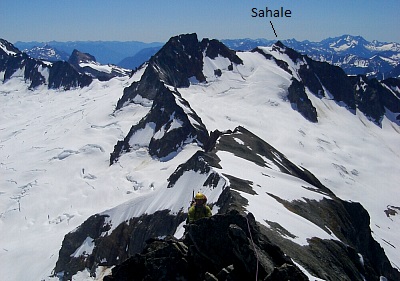


This trip almost never made it off the ground. First there was engine trouble with Scott's Land Cruiser. Fortunately we were only 10 minutes from home and we were able to quickly re-pack our gear into Chris's car. Then, a few miles outside of Marblemount, Chris's timing belt quit. It was about 10pm at the time and we were fortunate to hitch a ride back into Marblemount at that hour. Once in town, we arranged to have the car towed to the Honda dealership in Burlington and negotiated with the locals to give us a ride to the trailhead, some 20 miles up the Cascade River Road. Chris also arranged to have his dad pick us up on Sunday afternoon.

Annoyingly, during all this ad hock planning and negotiating, we were being continuously heckled by a crazy-eyed, Jesus look-alike who had obviously consumed way too much acid at some point in his life. After what seemed like an eternity, we were finally dropped off at the gate (near Eldorado trailhead) and proceeded to mat down some tall grass on the side of the road for our tent. By morning the weather had deteriorated, bringing occasional showers. We met several returning parties on our way up to the trailhead...all sporting long faces. Reports of continuously foul weather did little to bolster our enthusiasm. Still, we decided to go and I endured the next few hours trying to reassure Chris to keep going as I felt confident that the weather on Sunday would improve.

Late afternoon view to the WSW from the Quien Sabe Glacier. Funny how weather can be so fickle sometimes - all of Saturday we were hiking through rain and fog, then late in the day the clouds gave way to sunshine. The following morning yielded excellent cramponing conditions and we made record time reaching the Boston-Sahale Col. Looking down the Quien Sabe Glacier, our camp was but a tiny speck below encroaching slough-slides. I traversed below the heavily-corniced summit ridge and kicked steps as I went, to secure better footing on the way back down. Chris and Scott followed my track around the corniced ridge and stopped at the level bench just below the final summit rocks...still covered in snow.

The final few feet were suprisingly steep and exposed. Upon descending back to the bench, Chris, who had just arrived, urged me to rope-up with him and head back up to the summit. Somewhat shaken by the sketchy descent, I declined. A few more careful steps back around the corniced ridge and we were back at the col and glissading down what was now rapidly becoming shin-deep slush. As we were packing up camp, we were passed by several individuals making slow, laborious progress up the loose, wet snow. It didn't look particularly enjoyable for them. But anyway, this was a fun climb and a great introduction to the Cascade Pass area peaks!

Click here to view photos.
home | email | copyright

All photos and text for sverdina.com are copyright © 2002-2024

It would be very much appreciated if you please ask before copying and/or re-publishing content from any part of these pages. To do so, please click here to send a message via feedback form.

Thank You.

©2024 sverdina.com |