


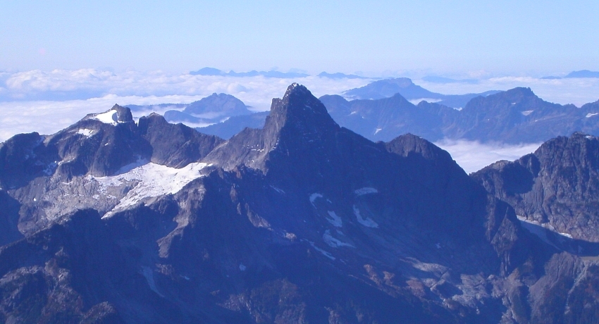
West McMillan Spire - West Ridge, September 2004
 as seen from the approach into Terror Basin.")
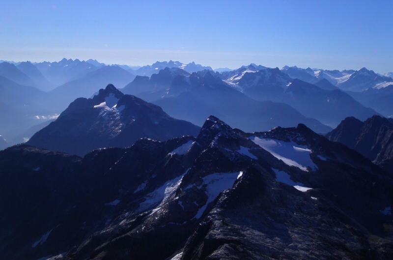
After not having climbed anything of significance together for most of the summer, Tom and I finally paired up for what would be our first venture into the Southern Pickets. Though the West Ridge of West McMillan Spire isn't much of a technical mountaineering objective, this is one climb that must be appreciated for what it is - namely, a quick and dirty (relatively speaking) scramble to the top of a remote summit in the spectacular and seldom visited wild and untamed Picket Range. To say that the summit views were anything other than outstanding would be sacrilege.
Yet another Beckey first ascent (Fred and Helmy), the approach to West McMillan Spire (WMS) is a real doozie. Starting at a surprisingly low 600ft, the first 4 miles of easy, mostly flat trail (actually an abandoned logging road) might lull the unsuspecting climber into thinking that the approach is a breeze. The deceivingly up-close glimpses of the Chopping Block and WMS from near the trailhead would also appear to support this notion. Only when one begins the brutally steep grind up into Terror Basin - from trail/road-end at 1700ft to roughly 5000ft, does an appreciation for climbing in The Pickets really hit home. Fortunately, since publication of Jim Nelson's Selected Climbs v.1 book, WMS has increased in popularity such that the notoriously thick brush (another Picket staple) has surrendered a viable, if not masochistic climber's path up out of the Goodell Creek Valley. Whereas parties once took 3, maybe 4, days for this climb, WMS can easily be completed in a day-and-a-half today. That being said, both Tom and I scoff at Eric Hoffman's assertion that this climb can be done in just one day from the trailhead...well, perhaps if your name is Dan Howitt. But, I digress...
With a before-sunrise departure from Seattle, I allowed myself the rare luxury of being chauffeured in Tom's 80's-vintage Nissan 300ZX. As others often do when it's my turn to drive, I found myself nervously clutching the OH SHIT bar as Tom casually obliterated the posted speed limit en route to Darrington. With only a minor, albeit half-expected snafu involving a flat, we made decent time getting to Marblemount. We turned left off hwy20 just before Newhalem immediately after crossing over Goodell Creek. Taking a left at the "T" intersection, we continued past a road maintenance facility and drove on gravel road a short distance to a fork. Taking the right fork, we soon reached a small campground and parked (fits 3 or 4 cars max).
An obscure trail through a visually pleasing moss-covered forest floor takes off just beyond the campsites and reaches a large, washed-out creek crossing in about a mile. Cross the creek (mostly dry for us) and climb up the opposite bank. Poke around for the trail continuation in a small clearing just beyond the bank (watch for flagging). If you find yourself thrashing though forest while paralleling the creek, or, for that matter, hiking up along the creek bed as we did, you're off route. Continue up the trail until a small fire pit and campsite is reached. We located a trail cutting back at right - this is the Terror Basin climber's path and where the fun really begins.
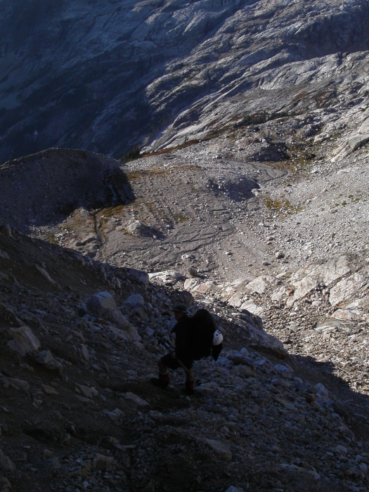
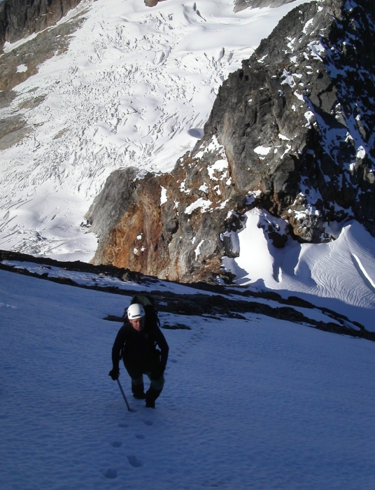
The path progressively steepens as it switchbacks up through heavy timber, eventually reaching open heather meadows at about 5000ft. We followed the path as it made an ascending northward traverse and lost it somewhere after the final rocky streambed crossing (hike up along N side of stream to locate path again). Continuing on the same trajectory, we located the worn path and followed it as it traversed heather benches up to an obvious notch in the ridge (~6200ft). From the notch, we descended steep scree and talus at the extreme right side (beware of rockfall), before traversing back left to campsites in a wide gravel basin about 400ft below the notch (~6.5 hrs from the car).
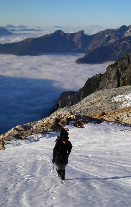
Once at camp, we would soon acquaint ourselves with none other than CC.com's very own "Juan" (John Sharp), "DPS" (Dan Smith), "Wazzumountaineer" and "Fleblebleb". We chatted briefly before setting up our tent, myself growing increasingly concerned with John's obvious interest in the pint of whisky I was carrying. The sun went down, and with dinner consumed we sat together with our camp neighbors and shared stories, whiskey and cigarettes. With the other party about 30min ahead of us, we left camp the next morning a little after first light. We contoured over heather benches, then polished slabs towards the outlet of a hidden glacial lake at about 5500ft. Crossing the lake outlet, we continued up polished slabs to the small glacier beneath WMS. The glacier crossing was casual, and with about 6 inches of new snow covering hard ice and crevasses no more than a few feet deep, we easily booted up towards the gully below the West Ridge.
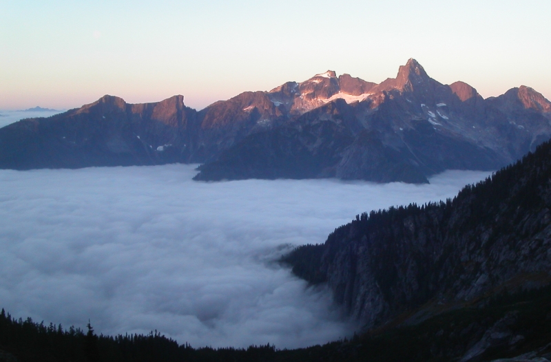
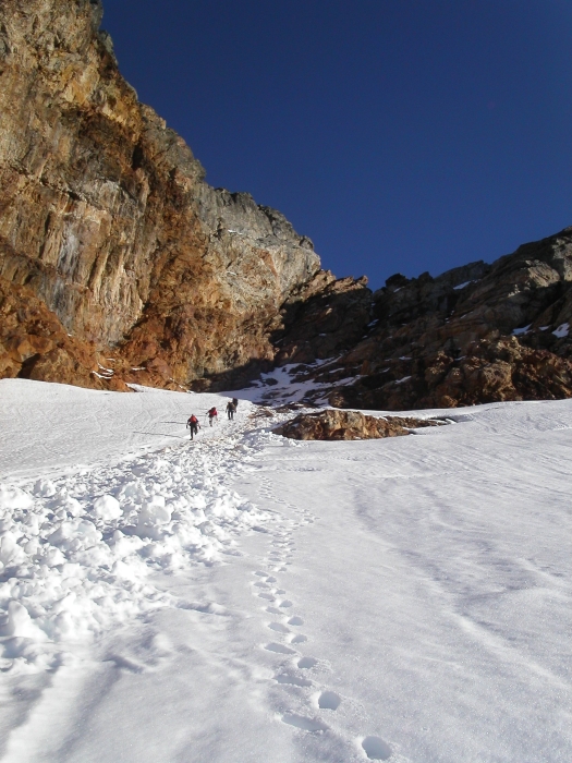
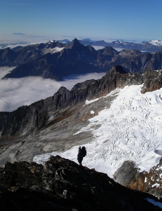
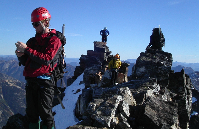
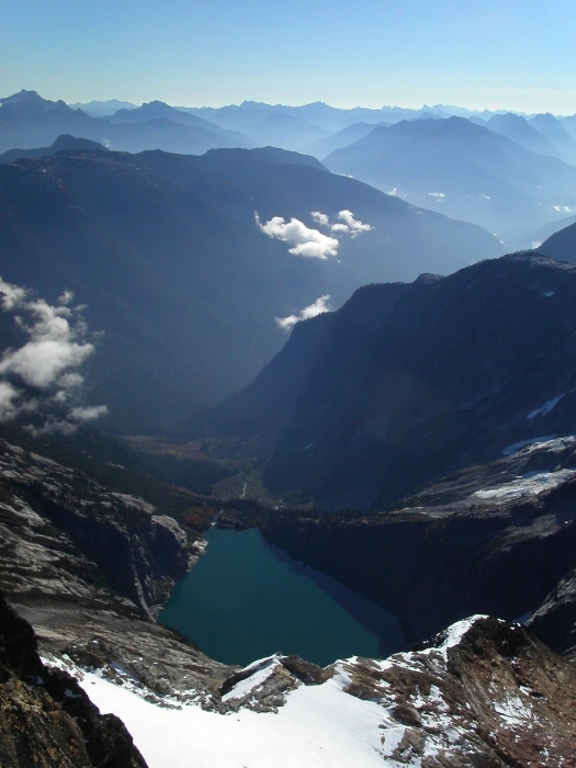
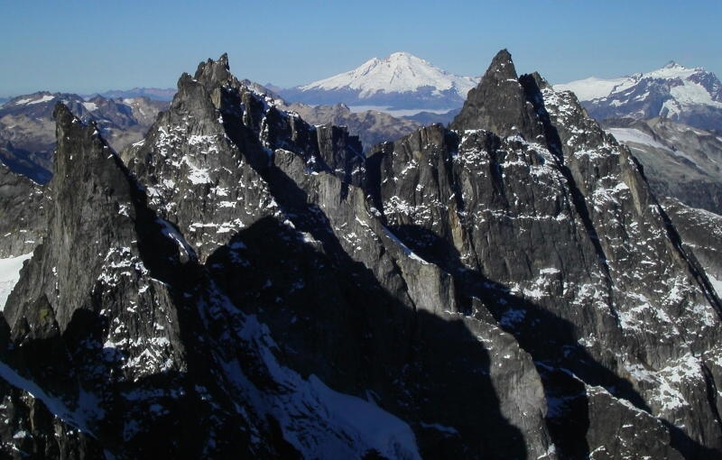
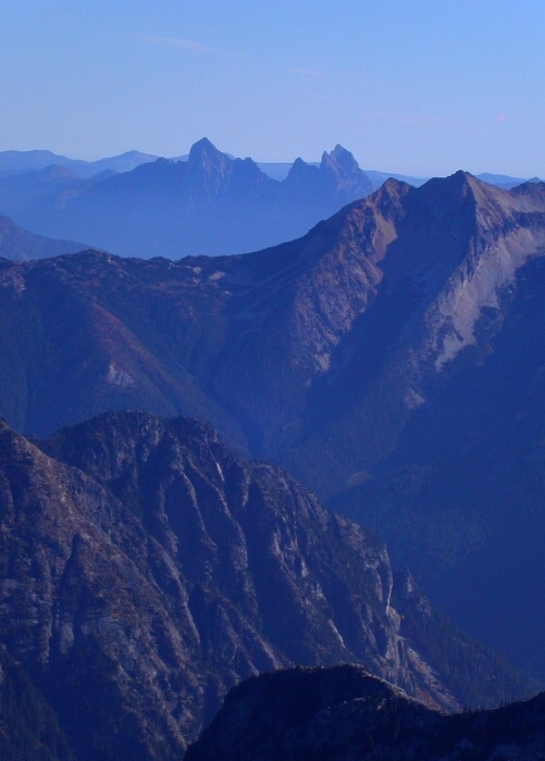
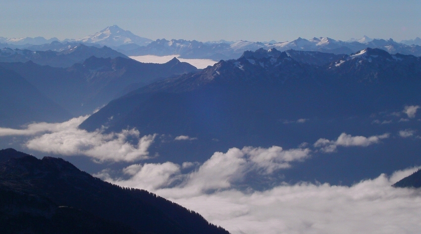
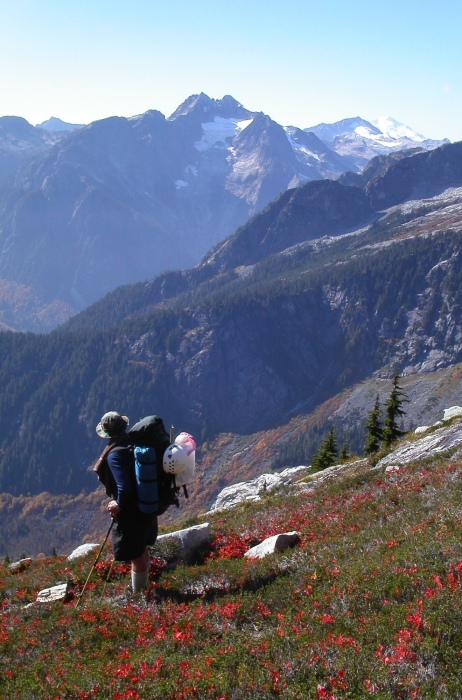
Waiting briefly for the other party to complete their ascent of the wet snow and scree filled gully, Tom and I took pause to survey the surrounding scenery. The low fog filling nearby valleys and lowlands to the west was beginning to lift. Yup, these are definitely some primo views; among the best in the Cascades I would venture to say. Once on the broad West Ridge itself, we scrambled up mostly 3rd-class rock (some 4th) and unavoidable patches of fresh, firm snow to the narrow summit ridge. John Sharp and company was just beginning to vacate the summit area (Wazzumountaineer, John, Dan and Tom left-to-right) as we arrived; that was the last we would see of each other. With stunning views of Mt. Triumph to the west, Fury's Southeast Glacier to the north, Hozomeen Mountain to the east and the bulk of the North Cascades to the south, there was much to look at. Nearby Inspiration Pk., Mt. Degenhardt and Mt. Terror were also quite hard to ignore. We weren't in a hurry to leave and happily basked in the late September sunshine...if only we didn't have to bother with that annoying descent back to the car. My thighs were sore for a good three days afterwards. The fond memories will persist for a while longer I'm sure.
Click here to view photos.
![]()


