Last Updated: September 7, 2024


Start

Recent content updates are viewable under what's new.

Reports in the queue for posting are coming soon!

Upcoming reports & photos:

Oh my! Quite the backlog here...

  • Mount Hanover - scramble (August 2023)
  • Lizzie Lake (Long, Tynemouth, Arrowhead, Tabletop & Anemone) - scramble (August 2023)
  • Armchair Traverse - scramble (August 2023)
  • Snowspider Mountain - scramble (September 2023)
  • Mount Trorey - scramble (September 2023)
  • Macleod Peak - scramble (September 2023)
  • Ben Lomond - scramble (September 2023)
  • Mount Killam (Gambier Island) - hike (September 2023)
  • Lone Goat & Snow Camp Mountain - hike (September 2023)
  • Isollilock Peak - scramble (October 2023)
  • Mount Manson - Mount Hatfield Traverse - scramble (October 2023)
  • The Gargoyles & Columnar Peak - scramble (October 2023)
  • Opal Cone and Lava Glacier - hike (October 2023)
  • Park Butte (WA) - hike (October 2023)
  • Trappers Peak (WA) - scramble (October 2023)
  • Rattlesnake Ledge (WA) - hike (November 2023)
  • Sauk Mountain (WA) - hike (November 2023)
  • Sunshine Coast (Mount Daniel, Pender Hill) - hike (November 2023)
  • Mount Dickerman (WA) - hike (November 2022)
  • Verona Peak AKA Winter's End - snowshoe (November 2023)
  • Dolomites (IT) - snowboard (December 2023)
  • Red Rock Canyon (NV) - scramble (January 2024)
  • Flute Summit & Oboe Summit - snowboard (February 2024)
  • Whistler Miscellaneous (Train Wreck, Loggers Lake, Shadow Lake and more) - hike (February 2024)
  • Mount Underhill - hike (March 2024)
  • Bombtram Mountain - snowshoe (March 2024)
  • Steep Peak - snowboard (March 2024)
  • Ruby Mountain (WA) - snowshoe (April 2024)
  • Blustry Mountain - hike (April 2024)
  • Sowerby Peak (Barr East) - snowshoe (April 2024)
  • Picacho Peak (AZ) - hike (April 2024)
  • Kitt Peak Observatory (AZ) - (April 2024)
  • Mount Wrightson (AZ) - hike (April 2024)
  • Saguaro National Park (AZ) - April 2024)
  • Superstition Peak/Benchmark (AZ) - scramble (April 2024)
  • Mount Humphreys (AZ) - hike (May 2024)
  • Petrified Forest National Park (AZ) - (May 2024)
  • Piestewa Peak (AZ) - hike (May 2024)
  • Channeled Scablands (WA | Columbia Gorge, Ancient Lakes, Potholes Lake, Palouse Falls and more) - hike (May 2024)
  • Rhododendron Mountain ("Pk. 2220") - snowshoe (June 2024)
  • Flora Peak - hike (June 2024)
  • Gibson Peak - snowshoe (June 2024)
  • Mount Urquhart - scramble (June 2024)
  • Rock Mountain (WA) - hike (July 2024)
  • Ladies Pass Quartet (WA | Cape Horn, Ladies Peak, Snowgrass NE Peak, Snowgrass Mountain) - scramble (July 2024)
  • Old Snowy (WA) - scramble (July 2024)
  • Dog Mountain (WA) - hike (July 2024)
  • Mount Ratney & Mount Bardean - scramble (July 2024)
  • Torrent Peak - scramble (July 2024)
  • Steep Peak - Darkside Peak Traverse - scramble (July 2024)
  • Silvertip Mountain - scramble (July 2024)
  • The Old Settler - scramble (July 2024)
  • Silent Hub Peak - scramble (August 2024)
  • Saint Jacobs Mountain - scramble (August 2024)
  • Mount David (WA) - scramble (August 2024)
  • Goat Mountain West Peak & Table Mountain (WA) - scramble (August 2024)
  • Griswold Pass (Tuber Hill, Glacier View Peak, Subatomic Peaks: Baryon, Meson, Muon, Lepton) - scramble (September 2024)
  • Yellow Aster Butte (WA) - scramble (September 2024)
  • Mazama Dome (WA) - scramble (September 2024)
  • Ptarmigan Ridge - (WA | The Portals East Peak, Coleman Pinnacle) - scramble (September 2024)
  • Tetrahedron Peak - scramble (September 2024)
  • Lone Cone & Peak 86 (Tofino) - hike (September 2024)
  • Mount Athelstan ("Pk. 2460") - scramble (September 2024)
  • Excelsior Peak and Cowap Peak - hike (October 2024)

*As of 10/05/2024


Database

Query the reports database, selecting from criteria which include name, location, type, season etc.

Quick Links

Essential links & whatnot:


Jump To

Select from list below to jump to a specific area on this site.


| Featured Trip Report |


Last Updated: May 23, 2008

Mount Hardy - "OpenFly Coulior", May 2008
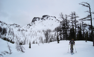


With hwy20 having opened not two days prior, the race was on to harvest what was left of the pow, before the masses and/or freeze/thaw rendered the slopes a bumped-out crud fest. What to do, what to do? Let's see, Silverstar, Birthday Tour, Maple and Rainy Passes - been there, done that...aha, but wait! Phil Fortier had posted a couple trip reports a few years back of ski descents on Mt. Hardy's north side: NE Coulior and "Open Fly Coulior". These features seemed intriguing enough to lure Tod and me to go have a look for ourselves.

Starting from the plowed pullout near the Easy Pass Trailhead, Tod and I crossed the road and maintained a steady ascending traverse bearing to the southeast, with only one steep stream crossing worth noting before turning up a broad timbered rib. Before long, the rib eased back and gave way to mostly open slopes beneath the 7600ft western sub-summit of Hardy, referred to as "Nancy Drew" in Phil's report. We continued up to a gentle saddle just left of "Nancy Drew" to scope out what would be our return route back up from Swamp Creek Valley. It seemed simple enough - a wide-open bowl, with an hourglass section lower down leading to an apron above the valley floor.

From the saddle, we contoured across the small south-facing bowl aiming for a minor ridge dividing "Nancy Drew" from Hardy's main summit. When the going got too steep for skinning, we strapped our skis to our packs and booted up the ridge to a small notch right at the peak's summit. A quick reconnaissance by Tod indicated that the entrance to Phil's "Open Fly Coulior" was just off to the right. A short down-climb soon saw us the top of the coulior where we were relieved to learn that it wasn't necessary to rappel into.

Tod dropped in the 40 degree-ish coulior first. We encountered maybe three-to-four inches of powder over a frozen and unpredictably lumpy base. Occasionally we'd get a good slash turn, but more often than not the thin coating of powder concealed knee-jarring, re-frozen avalanche debris hidden underneath. Triggered by our turns above, a sluff chute was constantly running down the gut of the coulior - a flowing river we'd frequently have to cross in search of a mercifully forgiving patch of powder. The aesthetic slot coulior narrowed briefly to about 10 feet before opening-up for the remaining descent to the valley floor. The powder gave way to sticky glop near the bottom, with monitor-sized avalanche chunks choking the exit to the apron below. Below this, a smooth lower-angled corn slope finally offered up some of the best turns of the day. All told, I think we spent no more than ten minutes 'leap-frogging' down the coulior - you decide if the payoff justifies the near $4/gallon gas price tag just to drive here in the first place.

After a brief lunch break (it was already 3 pm), we skinned-up and began traversing (skier's) right towards the previously noted hourglass below our return saddle. The slope angle through the hourglass was fairly steep and also choked with avalanche debris, making for an exhausting and time-consuming two-steps-forward, one-step-back grunt to reach the bowl above. We eventually regained the saddle without further difficulty and rested briefly as the snow showers continued to intensify. To return, we rode smooth corn roughly along our initial up-track on Hardy's south-facing slopes, before dropping into alternating gladed and/or forested terrain. Eventually the forest became too dense to reasonably link turns, so we sideslipped between trees and branches for a good portion of the descent before eventually resorting to booting. We reached the road about ten minutes afterwards, and had only about a half-mile of walking in the rain to return to where we parked at the Easy Pass pullout.

Looking over my shoulder, I was hopeful that Phil and Dave would happen to be driving by and return the favor of shuttling us to the car. After all, we saved them a good 3 or 4 miles of road slogging back in 2004, when they were returning from their initial Mt. Hardy ski descent! Next time fellas, right?

Click here to view photos.
home | email | copyright

All photos and text for sverdina.com are copyright © 2002-2024

It would be very much appreciated if you please ask before copying and/or re-publishing content from any part of these pages. To do so, please click here to send a message via feedback form.

Thank You.

©2024 sverdina.com |