Last Updated: October 19, 2024


Start

Recent content updates are viewable under what's new.

Reports in the queue for posting are coming soon!

Upcoming reports & photos:

Oh my! Quite the backlog here...

  • Lizzie Lake (Long, Tynemouth, Arrowhead, Tabletop & Anemone) - scramble (August 2023)
  • Armchair Traverse - scramble (August 2023)
  • Snowspider Mountain - scramble (September 2023)
  • Mount Trorey - scramble (September 2023)
  • Macleod Peak - scramble (September 2023)
  • Ben Lomond - scramble (September 2023)
  • Mount Killam (Gambier Island) - hike (September 2023)
  • Lone Goat & Snow Camp Mountain - hike (September 2023)
  • Isollilock Peak - scramble (October 2023)
  • Mount Manson - Mount Hatfield Traverse - scramble (October 2023)
  • The Gargoyles & Columnar Peak - scramble (October 2023)
  • Opal Cone and Lava Glacier - hike (October 2023)
  • Park Butte (WA) - hike (October 2023)
  • Trappers Peak (WA) - scramble (October 2023)
  • Rattlesnake Ledge (WA) - hike (November 2023)
  • Sauk Mountain (WA) - hike (November 2023)
  • Sunshine Coast (Mount Daniel, Pender Hill) - hike (November 2023)
  • Mount Dickerman (WA) - hike (November 2022)
  • Verona Peak AKA Winter's End - snowshoe (November 2023)
  • Dolomites (IT) - snowboard (December 2023)
  • Red Rock Canyon (NV) - scramble (January 2024)
  • Flute Summit & Oboe Summit - snowboard (February 2024)
  • Whistler Miscellaneous (Train Wreck, Loggers Lake, Shadow Lake and more) - hike (February 2024)
  • Mount Underhill - hike (March 2024)
  • Bombtram Mountain - snowshoe (March 2024)
  • Steep Peak - snowboard (March 2024)
  • Ruby Mountain (WA) - snowshoe (April 2024)
  • Blustry Mountain - hike (April 2024)
  • Sowerby Peak (Barr East) - snowshoe (April 2024)
  • Picacho Peak (AZ) - hike (April 2024)
  • Kitt Peak Observatory (AZ) - (April 2024)
  • Mount Wrightson (AZ) - hike (April 2024)
  • Saguaro National Park (AZ) - April 2024)
  • Superstition Peak/Benchmark (AZ) - scramble (April 2024)
  • Mount Humphreys (AZ) - hike (May 2024)
  • Petrified Forest National Park (AZ) - (May 2024)
  • Piestewa Peak (AZ) - hike (May 2024)
  • Channeled Scablands (WA | Columbia Gorge, Ancient Lakes, Potholes Lake, Palouse Falls and more) - hike (May 2024)
  • Rhododendron Mountain ("Pk. 2220") - snowshoe (June 2024)
  • Flora Peak - hike (June 2024)
  • Gibson Peak - snowshoe (June 2024)
  • Mount Urquhart - scramble (June 2024)
  • Rock Mountain (WA) - hike (July 2024)
  • Ladies Pass Quartet (WA | Cape Horn, Ladies Peak, Snowgrass NE Peak, Snowgrass Mountain) - scramble (July 2024)
  • Old Snowy (WA) - scramble (July 2024)
  • Dog Mountain (WA) - hike (July 2024)
  • Mount Ratney & Mount Bardean - scramble (July 2024)
  • Torrent Peak - scramble (July 2024)
  • Steep Peak - Darkside Peak Traverse - scramble (July 2024)
  • Silvertip Mountain - scramble (July 2024)
  • The Old Settler - scramble (July 2024)
  • Silent Hub Peak - scramble (August 2024)
  • Saint Jacobs Mountain - scramble (August 2024)
  • Mount David (WA) - scramble (August 2024)
  • Goat Mountain West Peak & Table Mountain (WA) - hike (August 2024)
  • Griswold Pass (Tuber Hill, Glacier View Peak, Subatomic Peaks: Baryon, Meson, Muon, Lepton) - scramble (September 2024)
  • Yellow Aster Butte (WA) - hike (September 2024)
  • Mazama Dome (WA) - hike (September 2024)
  • Ptarmigan Ridge - (WA | The Portals East Peak, Coleman Pinnacle) - hike (September 2024)
  • Tetrahedron Peak - scramble (September 2024)
  • Lone Cone & Peak 86 (Tofino) - hike (September 2024)
  • Mount Athelstan ("Pk. 2460") - scramble (September 2024)
  • Excelsior Peak and Cowap Peak - hike (October 2024)
  • Hollyburn Peak - hike (October 2024)
  • Cheam Peak - hike (October 2024)
  • Blanchard Needle - scramble (October 2024)

*As of 10/13/2024


Database

Query the reports database, selecting from criteria which include name, location, type, season etc.

Quick Links

Essential links & whatnot:


Jump To

Select from list below to jump to a specific area on this site.


| Featured Trip Report |


Last Updated: January 23, 2007

Jim Hill, January 2007


Please forgive the repetition, but it's been another a winter of chair lifts and the pillaging of lift-accessed backcountry for me...which explains the dearth of b/c reports so far. What can I say? Take the excellent snow conditions we've enjoyed this season, and mix in some expert 'slope management' not to mention a keen awareness for the finer lines, and you've clocked the equivalent vertical feet-per-day of say 10 Jim Hill's. I know, I know...what gluttons we are.

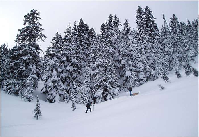
But alas, lest we become hopelessly lazy and succumb completely to the mechanized convieniences society affords us, there's always a time and place for a backcountry tour. It had been about a week since the last dump - slopes at the resorts were obviously shredded, but with daytime temps in Seattle below freezing all week long, the backcountry promised to deliver in droves. And so it came to be that Andy and I would finally stretch our legs for our first tour of the season.

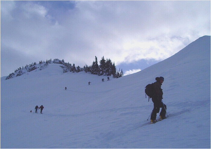
We rendezvoused with Jerry, Susan and Eric at the HWY2 pullout. Apparently we weren't the only ones gunning for Jim Hill on this day - there were about 10 cars parked there by the time we started skinning. In addition to our party, I counted fifteen or more people out on Jim Hill's slopes! Eric Houtkooper was also making the alternate Lanham Creek approach to Jim Hill with about twenty others in tow (we never saw Eric or his posse). I think Jerry was exaggerating the exact count, but it neverthess looked to be a seriously busy day on an otherwise relatively tame north facing slope. The race was on!

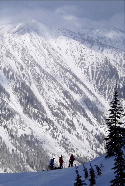
Once in the upper-bowl, Andy and I decided to continue on via Jim Hill's northwest-side in order to gain the same summit saddle Jerry and I did on our previous trip. Much to our dismay, clouds had enveloped the summit ridge by the time we got there making it very difficult to make out where exactly we were. Where was the saddle? Were we even looking down into the North Bowl? We tried waiting it out for a bit, but eventually grew impatient and cold and without a map instead opted to descend the way we came up. We re-joined the ridge crest somewhere above where Jerry and company had dropped-in and prepared for an entirely too-short ride back down the bowl. We continued all the way down to where Henry Creek drains from the lower basin and called it a day. Unfortunately, I don't have any action photos of our descent, but suffice to say they would have looked very much identical to those captured in this video clip. Heck, I even used the same home-made split this time! For the 2004 "Jim Hill" movie in it's entirety, click here. Oh, and one final word to the wise - absolutely under no circumstances should you consider returning via the east-side of Henry Creek. Believe me, however bad the west-side approach is, the east-side return is far worse!

Click here to view photos.
home | email | copyright

All photos and text for sverdina.com are copyright © 2002-2024

It would be very much appreciated if you please ask before copying and/or re-publishing content from any part of these pages. To do so, please click here to send a message via feedback form.

Thank You.

©2024 sverdina.com |