


Overseer Mountain - Southeast Slope, August 2009

Eli and I had time for one more Coast Range climb before making good on our already twice-revised plans and high-tailing it east for objectives in the Canadian Rockies. Sticking with a theme that had treated us well up until now, we narrowed our choices to a handful of selections from the Scrambles Guide. With the vast expanse of snow and ice surrounding the peak, I had always wanted to climb Overseer Mountain, preferably as a spring ski tour. However, approach and access considerations aside, the peak was just too far out of sight and mind to register on most of my Seattleite friends' radar. Hiking down from our Cirque Peak camp at mid-morning on a smoky Wednesday in August, it occurred to me that there was probably no better time than the present to go for Overseer. We had the time, favorable weather conditions, and were in the general area to boot. I could always come back in the spring sometime if I cared enough to 'board down it. Eli was of a similar opinion and so without further discussion we set our sights on the highest peak in the Pemberton Icefield.
So, what's the appeal? Save for perhaps the final summit tower, there isn't much in the way of 'climbing' to be had on Overseer's Southeast Face. Aside from an endlessly boring walk along a mostly flat glacier, the peak is really just a chosspile of epic proportions. Yes, there's a 4-pitch 5.8 rock climb on the peak's Southwest Face but that wasn't why we came. Looking up towards where we surmised the rock route starts I can say that there's an awful lot of loose and steep gully action just to get there in the first place. Given the length and arduousness of the approach to the Harrison Hut and beyond, not to mention the undeniably remote feel of the place, the idea of sketching up some vague and seldom climbed route on rock of dubious quality just wasn't calling us. Truth be told, all that's really required here is a fair amount of stamina, good route finding ability, and a passion for the path less trodden. Leave the gear behind and instead lose yourself in the isolation and grandeur of seemingly endless icescapes that harkens back to the Pleistocene. The reward is arguably one of North America's finest summit vistas within weekend range of a major metropolitan area. The cost? A brutal approach, a couple thigh-deep creek fords, and long, tedious battles with scree and talus. Is it worth it? Absolutely!
Famished after the descent from the Place Glacier glaciology huts, we first had ourselves a Mc'Lunch in Pemberton. We then dropped into a coffee shop to poach some free wifi and check in with loved ones. It wasn't till well after noon when we finally departed for Overseer. Speeding down the now familiar Pemberton Meadows Road, we turned onto the Lillooet River FSR and encountered a flagger who reminded us to slow down for the firefighting command center just ahead. The nearby Hurley forest fire had apparently flared-up again in the midday heat. Taking a left at the junction with the Hurley River FSR, we continued for what seemed like hours to the Meager Creek/Hot Springs turnoff. A short distance after the turnoff is a gate and signs warning that the area is among the most geologically unstable areas in Canada (if conditions warrant, the gate may be closed without notice). We convinced the custodian manning the gate that we weren't planning on using the hot springs and so he let us pass without paying the $5 fee. We reached the fancy new bridge over Meager Creek a short while later. The bridge was apparently rebuilt in 2005 after a massive washout took it out in 2003. Continuing across the bridge, Eli pointed out the unassuming Meager Creek Hot Springs entrance area. Styled in the character of a Japanese bathhouse, the hot springs feature numerous all-outdoor pools of varying sizes and temperatures and are well worth a visit...particularly after say a climb of Overseer Mountain!
We came to a complete stop after the switchback immediately following the bridge over Meager Creek. A stream must have burst its banks and temporarily flooded a section of the road at some point in the recent past. Although passable to trucks and probably most SUVs, the 100-yard long section of eroded gravel road wasn't drivable in Eli's Subaru WRX. We had hoped to at least make it an additional 4 kilometers to the overgrown spur road leading up the cutblock but this was not to be. Ok, let's see - 4km of forest road to spur PLUS 4km of switchbacks up cutblock PLUS 4.5 to 7 hours of 'trail' to hut...and all that starting around 4:00pm. Oh boy, good thing we didn't just hike down from Cirque earlier that day, eh? Oh, never mind. Um, let's toss-in our bivy sacks...you know, just in case! What's that Eli? "How bad do I want Overseer?" BAH! Enough of this blasphemy!
There's something really demoralizing about having to walk a perfectly drivable forest road only because a relatively small portion of it isn't passable. Once again, we weren't able rely on odometer readings to track our progress and our GPS wasn't jibing with the grid points from the guide. Nevertheless, locating the spur leading up the cutblock is fairly intuitive and comes a short distance after the second of two major creek crossings - Pika and Madhorse Creeks respectively. Note that in late September of 2009 a bridge over Meager Creek has been washed out at Capricorn Creek (past the hot springs I think). Access to the Meager branch has been restricted at the Lillooet River FSR. The logging spur is very overgrown in spots and features numerous water bars that would require aggressive driving to get past. Ignoring two or three right-branching forks, we reached the top of the cutblock marked by a cairn and flagging indicating the start of the climber's path. The road actually continues beyond this point, but it's obvious that this is the end for all vehicular traffic. Parched from the overbearing afternoon heat, Eli and I dove into the clear-cut at the forest's edge. Thanks to the occasional strips of flagging, staying on the steep and brushy path wasn't too much of a problem. Convinced that we wouldn't make it anywhere near the Harrison Hut that day, I kept a keen eye for a suitably flat bivy spot and hopefully also a water source. We encountered the first candidate after about an hour (about 6pm) - there was room for two, but water was nowhere to be seen. We still had a few hours of daylight left and so decided to press on.
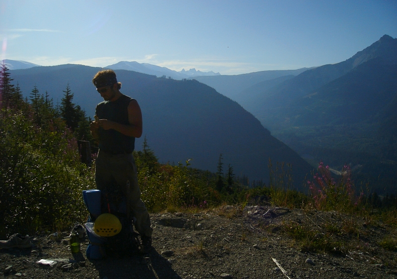
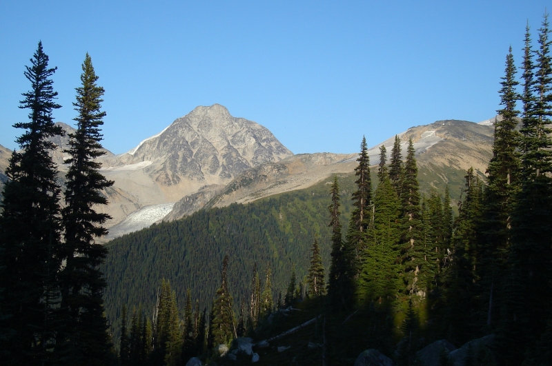
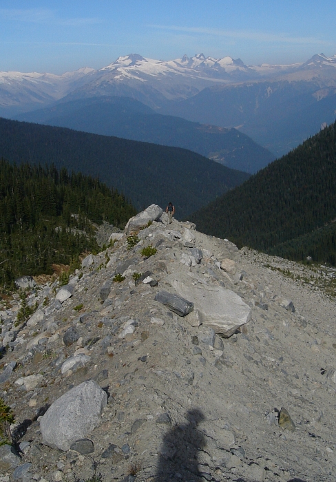
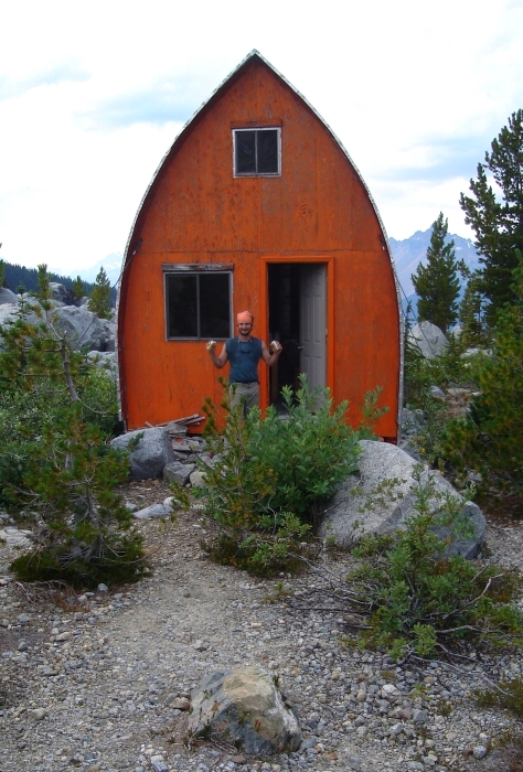
Forest started giving way to alpine meadow before long and muddy trickles transformed into small streams of clear, thirst-quenching water. Looking over our shoulders at left, a large hulking rock mass could be seen in the distance- we soon came to realize was Overseer Mountain itself. Now following increasingly sparse flagging and the occasional cairn, we began a long leftward traverse beneath the rocky ramparts of Pine Bump. Thrashing through a copse of evergreens we finally had an unobstructed view of the large moraine basin below us and for the first time noticed the unmistakable red paint of the Harrison Hut. Seeing the hut was powerfully motivating for me and caused me to pick up the pace in the fleeting hope that we'd make it there before dark. No way was I going to bivy out in the cold with a cozy hut so tantalizingly close! With just 30 minutes of daylight to spare, I jogged across the sandy moraine basin then descended a final talus slope to the edge of Madhorse Creek's South Fork. I managed to lose Eli in my haste and wasted precious minutes calling and looking for him before finally noticing a solitary figure standing at the creek's edge a hundred feet or so below me. Relieved that we wouldn't both be spending the night out alone, I made my way down to him. Pointing out an area of slower-moving water at a wider, braided portion of the creek, I suggested to Eli that this was probably the best place for a ford. In either case, we couldn't afford ourselves the luxury of locating a better place to cross and so got to removing our boots and rolling-up our pants. I barely noticed the chill of the knee-high water so fixated was I on the reaching the hut, and soon found myself standing on the opposite bank tossing my Croc's over to Eli.
Total darkness descended upon us moments after resuming our quest for the hut. A final grind up a short talus slope brought us to a flattish area littered with giant boulders. I knew the hut was at the edge of some trees but didn't want to make the mistake of traversing too low and missing it entirely. My prayers were finally answered when I noticed the light of my LED headlamp reflecting off the hut's sheet metal roof. It was about 9pm when Eli and I finally staggered though the front door. The two story hut is reasonably well appointed with Coleman cook tops, lanterns and a fireplace, not to mention the pots and pans, and various assorted 'emergency' provisions obviously left behind by previous guests. Reading through the entries in the guest book, it struck me how well frequented the hut is in winter and spring. Certainly the area makes for phenomenal ski terrain but just getting here that time of year seems very challenging. Even more surprising perhaps is the fact that the hut is a popular day-trip destination for snowmobilers traversing the Pemberton Icefield, many approaching from as far away as Callaghan Valley! The typical itinerary appears to go as follows - spend hours navigating the icefield by sled, chug a beer at hut and sign name in guestbook, spend hours returning across icefield. Brilliant! Then there's Matt Gunn's aptly named "Heli Scum" who fly into the area in the winter for a week or so of touring. Hmm, actually that doesn't sound so bad!
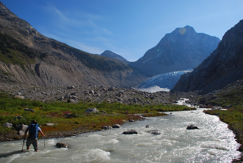
We had the hut to ourselves and enjoyed a reasonably restful night before our 6am wakeup call. Hopping boulders across the creek adjacent to the hut the following morning, we embarked on a steep trail-less grunt up to the crest of the shoulder (~6500ft) descending from Frozen Boot. Dropping down the other side we made a footsore rightward traverse losing most of the hard-earned elevation, only to hike back up again in order to gain the crest of a prominent lateral moraine. Walking along the sharp crest, we both dreaded the sight of what was to come next. Scratching down a steeply fluted moraine slope consisting of hard-baked silt and teetering boulders was easily the low-point of the trip. With the tedium finally behind us, we proceeded towards Madhorse Creek (North Fork). As in the previous instance, we chose to ford the creek where the water splits into two or more channels and seemed shallower and slower flowing than elsewhere. A returning party we encountered the previous day mentioned having been stymied by this creek crossing, so we were a bit apprehensive as to what to expect.
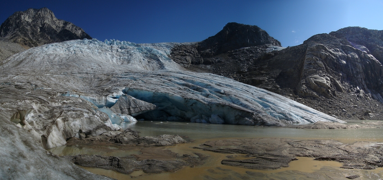
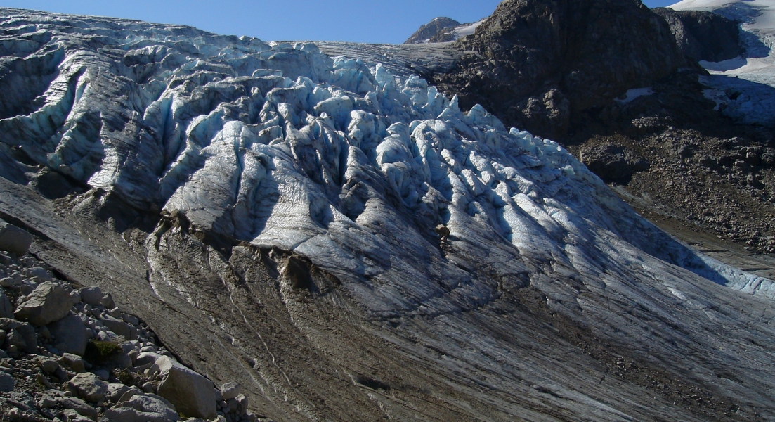
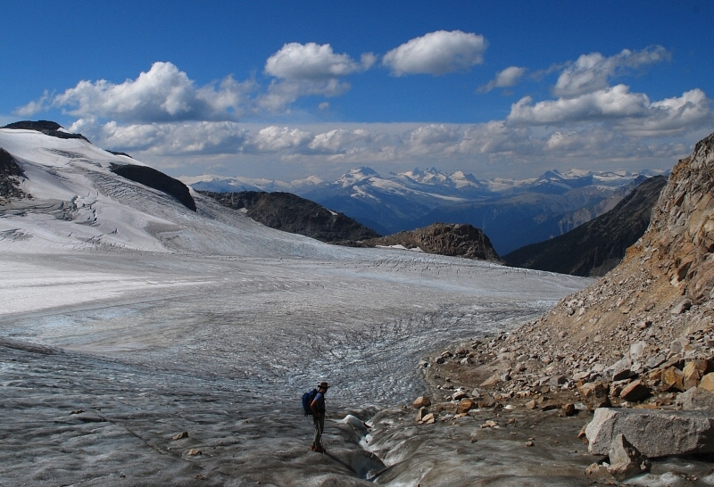
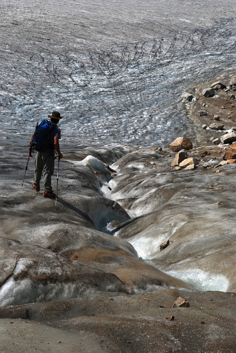
The crossing was fortunately no worse than before and we quickly found ourselves plodding across sandy dunes just west of a small moraine lake at the toe of Madhorse Glacier. Per the guide, we skirted the glacier snout and icefall by traversing horribly unstable talus slopes at (looker's) left. A MUCH better alternative would be to walk up moderately angled ice adjacent to the talus. We returned this way and encountered only one impasse, which briefly forced us back onto the talus. We hopped back onto the ice as the slope angle eased back. A long, casual walk, weaving around mostly flooded crevasses and fast-flowing troughs of melt water eventually saw us to the base of Overseer's Southeast Face.
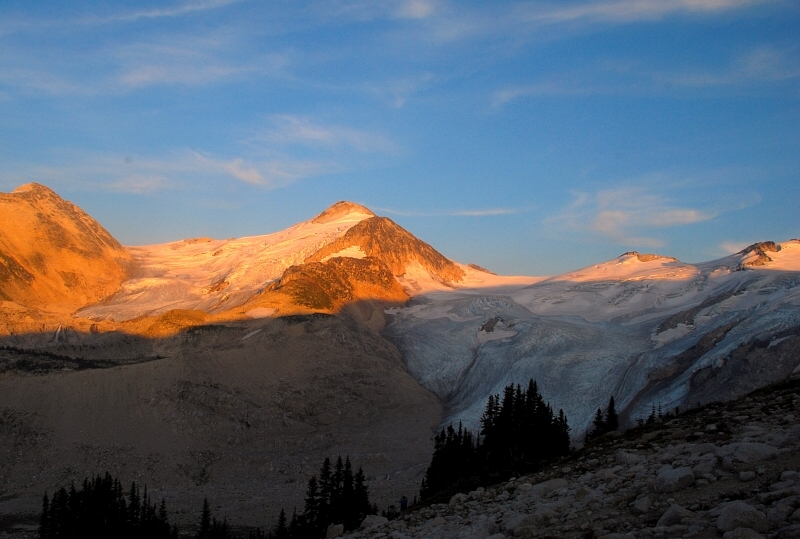
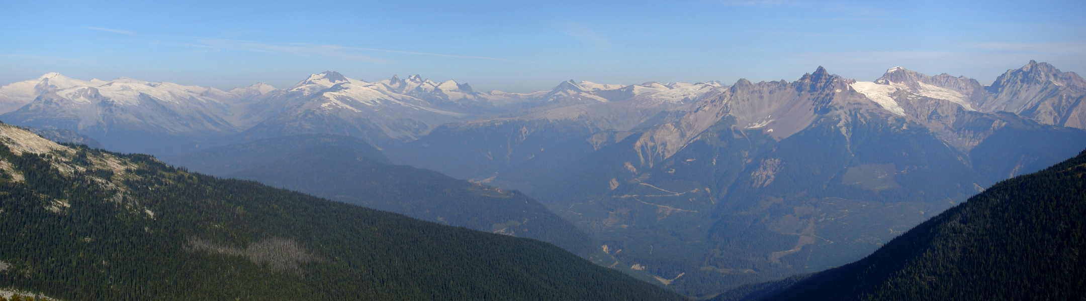
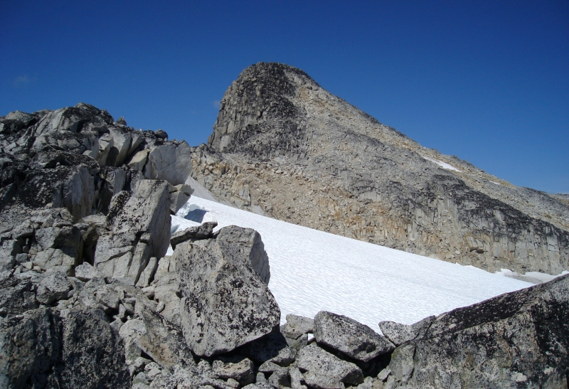
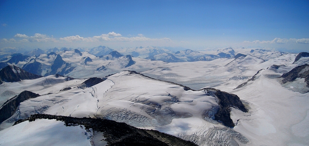
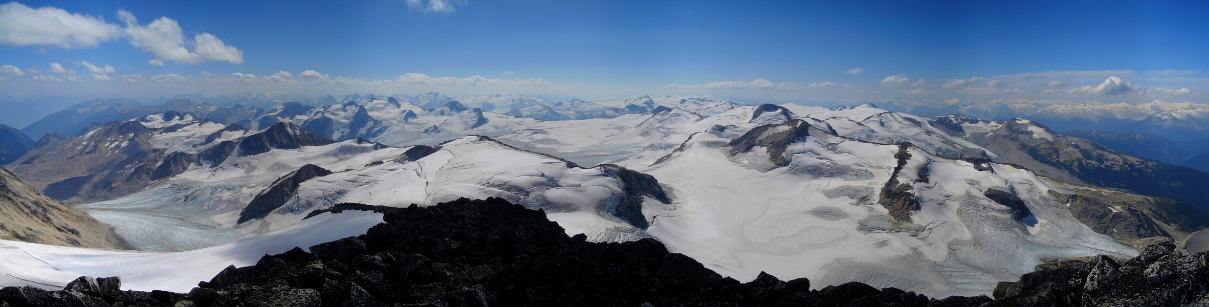
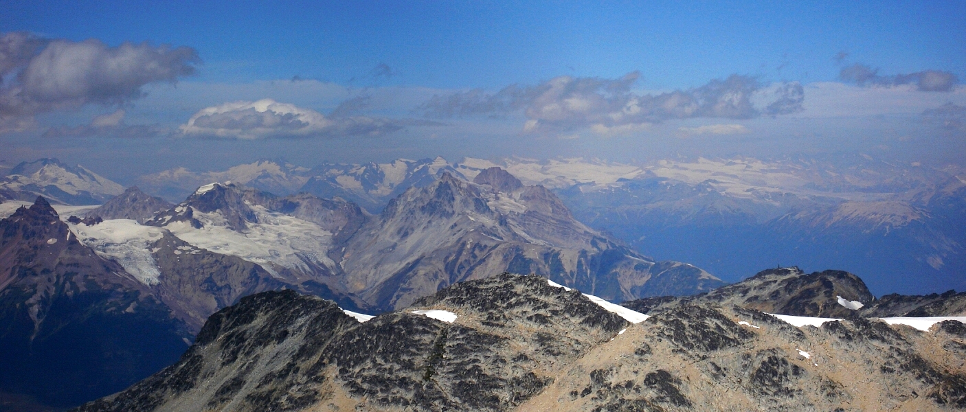
One look up the face and I think Eli decided he'd had enough fun with the talus and scree. Now on my own, I picked my way up the initial jumble of loose rocks. Avoiding a broad sandy gully at left (better on descent), I proceeded up increasingly solid (that's a relative term) lichen covered boulders, ledges and ramps to reach a broad bench below the final summit tower. Finally, I enjoyed some fun 3rd-class scrambling over flakes and large blocks to reach the summit proper. Words really can't describe the euphoria I felt standing up there, arms outstretched and breathing it all in. It's moments like these that keep me climbing year after year after year. Smoke obscured most of the views to the east but looking south the Pemberton Icefield was laid out before me, spanning a vast area from the Lillooet River Valley to the untamed wilderness of the upper-Meager Creek Valley.
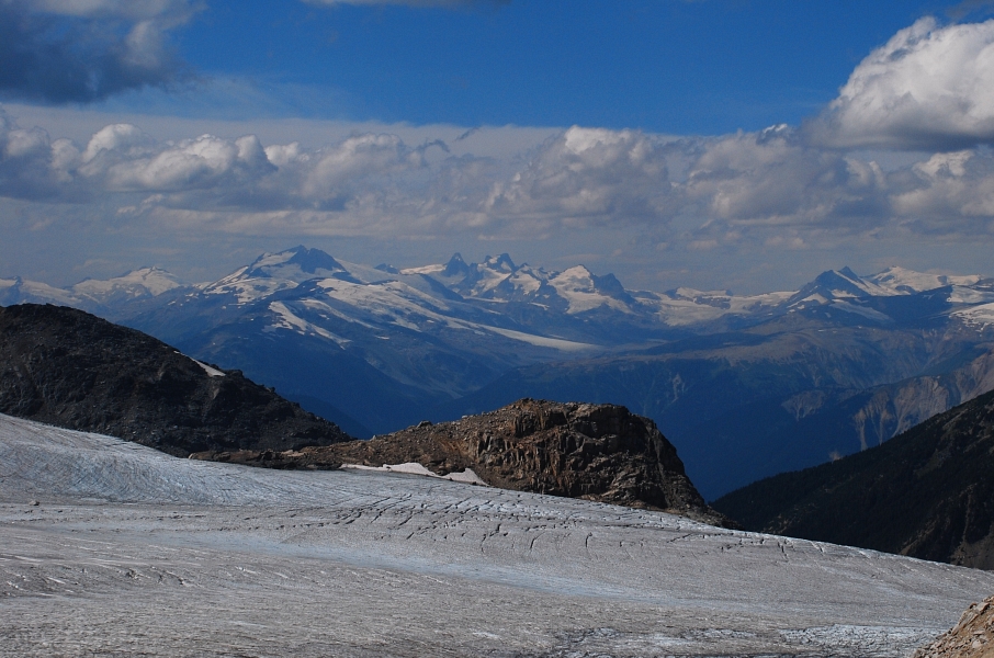
I could easily make out Mount Sampson through the haze, a peak I'd like to climb someday, and the closer-in peaks of the Manatee and Meager Groups. Serenia and Wahoo Tower are an unmistakable pair from most vantage points on the approach to the Harrison Hut not to mention Overseer itself. Volcanic chosspiles Mount Meager and Plinth Peak round out the visual smorgasbord near where Meager Creek drains into the Lillooet River. Lastly, far off glimpses of the Lillooet Icefield lying to the northeast, reminds one that the area around Overseer is really the proverbial tip of the iceberg when it comes to big peaks and expansive Coast Range ice fields. I've said it before, but the scale of the mountains, valleys and glaciers here is difficult for me to comprehend and at the same time also an unending source of inspiration.
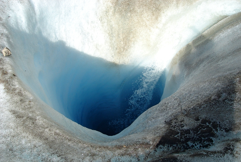
Alas, I could only revel in the high for so long before having to make my way back down. Taking the aforementioned sand and scree gully most of the way down from the bench below the summit, I rendezvoused with Eli back where we parted ways only two hours prior. We took some time to explore the glacier a bit on the descent and noted how some of the larger melt water troughs terminate in deep holes carved into the glacier. The Madhorse Glacier would make a great glaciology case study I think - there's certainly more going on here than the Place Glacier we had visited prior. Back at the Harrison Hut later that afternoon, Eli and I enjoyed a couple celebratory beers as thunderclouds began blowing in overhead. A party of two then joined us a short while later and together we stayed up long after sunset sipping whiskey and sharing climbing stories. Bidding our hut-mates farewell the next morning, we returned back to the car and were powerless to resist a soothing soak in the hot springs before finishing the long drive back to North Vancouver...and our next adventure!
Click here to view photos.
![]()


