Last Updated: December 14, 2024


Start

Recent content updates are viewable under what's new.

Reports in the queue for posting are coming soon!

Upcoming reports & photos:

Oh my! Quite the backlog here...

  • Mount Manson - Mount Hatfield Traverse - scramble (October 2023)
  • The Gargoyles & Columnar Peak - scramble (October 2023)
  • Opal Cone and Lava Glacier - hike (October 2023)
  • Park Butte (WA) - hike (October 2023)
  • Trappers Peak (WA) - scramble (October 2023)
  • Rattlesnake Ledge (WA) - hike (November 2023)
  • Sauk Mountain (WA) - hike (November 2023)
  • Sunshine Coast (Mount Daniel, Pender Hill) - hike (November 2023)
  • Mount Dickerman (WA) - hike (November 2022)
  • Verona Peak AKA Winter's End - snowshoe (November 2023)
  • Dolomites (IT) - snowboard (December 2023)
  • Red Rock Canyon (NV) - scramble (January 2024)
  • Flute Summit & Oboe Summit - snowboard (February 2024)
  • Whistler Miscellaneous (Train Wreck, Loggers Lake, Shadow Lake and more) - hike (February 2024)
  • Mount Underhill - hike (March 2024)
  • Bombtram Mountain - snowshoe (March 2024)
  • Steep Peak - snowboard (March 2024)
  • Ruby Mountain (WA) - snowshoe (April 2024)
  • Blustry Mountain - hike (April 2024)
  • Sowerby Peak (Barr East) - snowshoe (April 2024)
  • Picacho Peak (AZ) - hike (April 2024)
  • Kitt Peak Observatory (AZ) - (April 2024)
  • Mount Wrightson (AZ) - hike (April 2024)
  • Saguaro National Park (AZ) - April 2024)
  • Superstition Peak/Benchmark (AZ) - scramble (April 2024)
  • Mount Humphreys (AZ) - hike (May 2024)
  • Petrified Forest National Park (AZ) - (May 2024)
  • Piestewa Peak (AZ) - hike (May 2024)
  • Channeled Scablands (WA | Columbia Gorge, Ancient Lakes, Potholes Lake, Palouse Falls and more) - hike (May 2024)
  • Rhododendron Mountain ("Pk. 2220") - snowshoe (June 2024)
  • Flora Peak - hike (June 2024)
  • Gibson Peak - snowshoe (June 2024)
  • Mount Urquhart - scramble (June 2024)
  • Rock Mountain (WA) - hike (July 2024)
  • Ladies Pass Quartet (WA | Cape Horn, Ladies Peak, Snowgrass NE Peak, Snowgrass Mountain) - scramble (July 2024)
  • Old Snowy (WA) - scramble (July 2024)
  • Dog Mountain (WA) - hike (July 2024)
  • Mount Ratney & Mount Bardean - scramble (July 2024)
  • Torrent Peak - scramble (July 2024)
  • Steep Peak - Darkside Peak Traverse - scramble (July 2024)
  • Silvertip Mountain - scramble (July 2024)
  • The Old Settler - scramble (July 2024)
  • Silent Hub Peak - scramble (August 2024)
  • Saint Jacobs Mountain - scramble (August 2024)
  • Mount David (WA) - scramble (August 2024)
  • Goat Mountain West Peak & Table Mountain (WA) - hike (August 2024)
  • Griswold Pass (Tuber Hill, Glacier View Peak, Subatomic Peaks: Baryon, Meson, Muon, Lepton) - scramble (September 2024)
  • Yellow Aster Butte (WA) - hike (September 2024)
  • Mazama Dome (WA) - hike (September 2024)
  • Ptarmigan Ridge - (WA | The Portals East Peak, Coleman Pinnacle) - hike (September 2024)
  • Tetrahedron Peak - scramble (September 2024)
  • Lone Cone & Peak 86 (Tofino) - hike (September 2024)
  • Mount Athelstan ("Pk. 2460") - scramble (September 2024)
  • Excelsior Peak and Cowap Peak (WA) - hike (October 2024)
  • Hollyburn Peak - hike (October 2024)
  • Cheam Peak - hike (October 2024)
  • Blanchard Needle - scramble (October 2024)
  • Debeck's Hill & 4 Lakes Loop - hike (October 2024)
  • Mount Hallowell - hike (November 2024)
  • Anderson Mountain (WA) - hike (December 2024)
  • Sumas Mountain (WA) - hike (December 2024)

*As of 12/04/2024


Database

Query the reports database, selecting from criteria which include name, location, type, season etc.

Quick Links

Essential links & whatnot:


Jump To

Select from list below to jump to a specific area on this site.


| Featured Trip Report |


Last Updated: Mar. 25, 2002

Mount Rainier - Tahoma Glacier, August 2000 (plus Saint Andrews Rock)
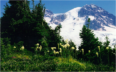


John and a couple of his friends had attempted this route a few weeks prior and were denied a summit thanks to a freak summer snow storm. He vowed to return and, along with myself invited a friend of his (forgot his name) who was visiting from California. We all took vacation from work and allocated 4 days in August for this climb.

We left early on a sunny Sunday afternoon and drove up to the Westside Road washout. After an endless 4 or 5 mile walk up the gravel road in the pounding heat we reached the trailhead. We were sweating profusely and quicky burned through all our water. We took any opportunity to filter what was available of the locally scarce running water into our water bottles. We soon gained a ridge and reached timberline shortly thereafter. We decided to set up camp next to a delightful little pond on a level bench with spectacular views westwards. We were starving by this point and unfortunately so were the swarming mosquitos.

Our first camp on the level bench. Aside from the murderous mosquitos, this was a perfect spot. We couldn't wait for nightfall when the cold would drive the pests away. We had unobstructed views to the west and spent the remaining daylight hours trying to make out any recognizable features in the distance far below us. We enjoyed an incredible sunset that evening. The following morning we passed by several scenic ponds on our way up the mountain. A lenticular cloud could be seen capping the summit while we broke for a snack at the base of Tokaloo Rock. The Puyallup Cleaver lay directly ahead of us while the massive Tahoma Glacier spilled down the mountain to the right. Mountain goats could be seen nearby. Perhaps the only permanent inhabitants of this seasonally harsh environment. We wondered what they were doing so close to the glacier.

We reached our high camp objective at the base of St. Andrews Rocks in good time. From our vantage point, the route off the Puyallup Cleaver onto the upper Tahoma Glacier appeared to be a nasty mix of icefall and crevasses. Having read something about an alternate route to the Tahoma Glacier via the top of St. Andrews Rocks, we decided to explore our options. Hiking up steep slush, we reached the ridge in hopes that an obvious route would take us over to the other side. John scouted ahead alone for the last several yards and for a moment I could not see or hear him and therefore feared the worst. Shortly thereafter he returned with his verdict...No Way. So, we once again pulled out the map, sat down and tried to find a way around.

Faced with few alternatives, we took another good look at the problematic Puyallup Cleaver/Tahoma Glacier intersection and more or less were able to piece together a route, albeit not the most direct one. We decided on an early but daylight start that next morning so as to be able to better navigate through the icefall. Because we would be starting relatively late and the sketchy conditions on the Tahoma Glacier, we decided to carry-over and descend via the DC route, confident that one of us would be able to bum a ride from Paradise back to the car.

As we were discussing our options, John's friend reported that he wasn't feeling too hot. Altitude sickness we feared. It was agreed that if his condition did not improve by morning we would abandon our summit attempt. That evening we were blessed with yet another spectacular sunset and wondered what the next morning would bring. Unfortunately John's friend's condition worsened by morning and so we packed up and climbed back down the mountain. Yet another failed attempt. To have to turn back in perfect weather for something totally out of my control – so frustrating! We spied more great views of Mt. Adams as we descended with heavy feet. I waited till next summer before making another attempt...

Click here to view photos.
home | email | copyright

All photos and text for sverdina.com are copyright © 2002-2024

It would be very much appreciated if you please ask before copying and/or re-publishing content from any part of these pages. To do so, please click here to send a message via feedback form.

Thank You.

©2024 sverdina.com |