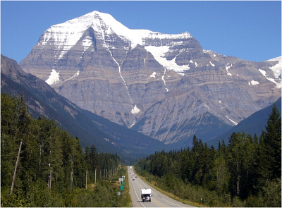
Mount Robson - Robson Glacier, August 2006

We drove to Robson Provincial Park, jaws dropping at the sight of the beast from the visitor's center. Without a doubt, Robson is far and away the most impressive mountain I have ever laid eyes upon (and that's just from the south-side)! We reserved our camps at Berg Lake and prepared to spend another 'glorious' night sleeping in the van. After discussing with the rangers we learned that nobody had made it up yet this year with recent parties claiming warm, unstable snow conditions on the Kain Face. Hopes weren't high, but we concocted a half-assed plan to pack minimally for a 4-day Robson trip and only go for it if reports from parties we encountered on the hike in were favorable (they were not). Hiking in, all we heard were tales of heinous travel through the Mousetrap (it is best to avoid the Mousetrap in this age of glacial recession by scrambling the ridge to its left) and loose mush and unstable layers of snow all on top of a deep layer of sugar. There was no ice to be found on the face! Uh oh...
Despite the less than favorable outlook we hiked the 15 miles with too-heavy packs to the Berg Lake camp. Wow! Needless to say, the views from this side of the mountain are captivating. We planned to at least make it to high camp on The Dome the next day and assess the conditions ourselves. Alas, we awoke to rain, thunder and lightning that first morning at Berg Lake Camp, and just returned to the tent for a few more hours of sleep instead. Plagued by motivational problems, we decided to make a go for Resplendent (a satellite of Robson), but seeing that it too was socked-in for most of the day we settled on just doing some glacier 'hiking'.
To make a long story short we ended-up making most of the Robson Glacier approach before the Mousetrap and climbed up to a glaciated highpoint (9500ft) marking the start of Resplendent's Icy Arete route. The clouds finally lifted late that afternoon revealing amazing views of the immense Robson Glacier curving out of view below us. Incredible! We briefly entertained the idea of traversing the ridge crest over to Lynx Mountain, but it was getting late in the afternoon and was time to return to camp. Looking down and left on our way back we noticed a mysterious solo climber wandering about below Resplendent's North Face.
We arrived back at camp later that afternoon as the weather continued to improve. Wandering about the lake shore later that evening, I stumbled upon a makeshift memorial to a fallen climber - if memory serves, enscribed on the plaque was something to the effect of "Hans Mosel...lost on Robson Glacier September 1947"??. I took a photo, of the crucifix and plaque, but the image came out a bit too dark to discern exactly what the text reads. I'd be interested to see if someone could perform some sort of "CSI-style" image enhancement to reveal the plaque text. Anyway, perhaps in part due to the solitude and the discovery of the memorial, I felt something deeply humbling and spiritual about this place.
We awoke to a perfectly cloudless morning the next day and Robson was out in all her glory - supposedly a rare occurrence. I wanted to make a 'quick' hike over to Snowbird Pass and get a view of the Reef Icefield, but with some 20 kilometers round-trip from camp plus an additional 15 kilometers to hike back out, it seemed bit too punishing to bother trying. In any case, our trip was rapidly coming to an end. Countless footsore miles eventually saw us back to the van. The visitor's center was swarming with tourists this time, so we high-tailed out of there opting to stop for lunch in Valemont instead. Though I have little good to say about the town's dining options, the Valemont liquor store is an oasis surrounded by a wasteland of abandoned motels and mobile homes.
Now back on the road, we "Yellowhead(ed) it" some 300 kilometers down the Thomson Valley to Kamloops. With roadside views of glaciated Albreda Peak and serene, Alps-like meadows and pasture land the otherwise monotonous drive offers plenty to look at. I was surprised to see a sign depicting the telltale Mike Wiegele Heli logo just outside Blue River (a blink-and-you'll-miss town). Having first learned of them many years ago while drooling over exquisite powder riding shots in Transworld Snowboarding Magazine, I'd always wondered where they based their operations. With the nearby Monashee mountains and Cariboo Mountains just a short heli-ride to the north, this is prime backcountry ski country...for those that can afford it at least!
After introducing Eric to Earls' Albino Rhino Ale and dry wings (and dinner), we made our way to the Knutsford RV Park and Campground just outside Kamloops. We played Gin Rummy for a while and then retired to the van for one final night of shitty sleep. Expecting to be harassed at the border, Eric and I were let though after no more than 3 questions. With the hood of the van a virtual graveyard of insect carcasses and us both sporting beards and dark tans, not to mention the climbing books strewn all over the dash and gear littered throughout the back, I guess we looked the part!
This being my third (Eric's second) trip to the Columbia and/or Rocky Mountains, we've still only barely scratched the surface of what the area has to offer. With so much left to discover and explore in our proverbial 'backyard', we'll be back again, and again...
Click here to view photos.


