Last Updated: January 18, 2025


Start

Recent content updates are viewable under what's new.

Reports in the queue for posting are coming soon!

Upcoming reports & photos:

Oh my! Quite the backlog here...

  • Park Butte (WA) - hike (October 2023)
  • Trappers Peak (WA) - scramble (October 2023)
  • Rattlesnake Ledge (WA) - hike (November 2023)
  • Sauk Mountain (WA) - hike (November 2023)
  • Sunshine Coast (Mount Daniel, Pender Hill) - hike (November 2023)
  • Mount Dickerman (WA) - hike (November 2022)
  • Verona Peak AKA Winter's End - snowshoe (November 2023)
  • Dolomites (IT) - snowboard (December 2023)
  • Red Rock Canyon (NV) - scramble (January 2024)
  • Flute Summit & Oboe Summit - snowboard (February 2024)
  • Whistler Miscellaneous (Train Wreck, Loggers Lake, Shadow Lake and more) - hike (February 2024)
  • Mount Underhill - hike (March 2024)
  • Bombtram Mountain - snowshoe (March 2024)
  • Steep Peak - snowboard (March 2024)
  • Ruby Mountain (WA) - snowshoe (April 2024)
  • Blustry Mountain - hike (April 2024)
  • Sowerby Peak (Barr East) - snowshoe (April 2024)
  • Picacho Peak (AZ) - hike (April 2024)
  • Kitt Peak Observatory (AZ) - (April 2024)
  • Mount Wrightson (AZ) - hike (April 2024)
  • Saguaro National Park (AZ) - April 2024)
  • Superstition Peak/Benchmark (AZ) - scramble (April 2024)
  • Mount Humphreys (AZ) - hike (May 2024)
  • Petrified Forest National Park (AZ) - (May 2024)
  • Piestewa Peak (AZ) - hike (May 2024)
  • Channeled Scablands (WA | Columbia Gorge, Ancient Lakes, Potholes Lake, Palouse Falls and more) - hike (May 2024)
  • Rhododendron Mountain ("Pk. 2220") - snowshoe (June 2024)
  • Flora Peak - hike (June 2024)
  • Gibson Peak - snowshoe (June 2024)
  • Mount Urquhart - scramble (June 2024)
  • Rock Mountain (WA) - hike (July 2024)
  • Ladies Pass Quartet (WA | Cape Horn, Ladies Peak, Snowgrass NE Peak, Snowgrass Mountain) - scramble (July 2024)
  • Old Snowy (WA) - scramble (July 2024)
  • Dog Mountain (WA) - hike (July 2024)
  • Mount Ratney & Mount Bardean - scramble (July 2024)
  • Torrent Peak - scramble (July 2024)
  • Steep Peak - Darkside Peak Traverse - scramble (July 2024)
  • Silvertip Mountain - scramble (July 2024)
  • The Old Settler - scramble (July 2024)
  • Silent Hub Peak - scramble (August 2024)
  • Saint Jacobs Mountain - scramble (August 2024)
  • Mount David (WA) - scramble (August 2024)
  • Goat Mountain West Peak & Table Mountain (WA) - hike (August 2024)
  • Griswold Pass (Tuber Hill, Glacier View Peak, Subatomic Peaks: Baryon, Meson, Muon, Lepton) - scramble (September 2024)
  • Yellow Aster Butte (WA) - hike (September 2024)
  • Mazama Dome (WA) - hike (September 2024)
  • Ptarmigan Ridge - (WA | The Portals East Peak, Coleman Pinnacle) - hike (September 2024)
  • Tetrahedron Peak - scramble (September 2024)
  • Lone Cone & Peak 86 (Tofino) - hike (September 2024)
  • Mount Athelstan ("Pk. 2460") - scramble (September 2024)
  • Excelsior Peak and Cowap Peak (WA) - hike (October 2024)
  • Hollyburn Peak - hike (October 2024)
  • Cheam Peak - hike (October 2024)
  • Blanchard Needle - scramble (October 2024)
  • Debeck's Hill & 4 Lakes Loop - hike (October 2024)
  • Mount Hallowell - hike (November 2024)
  • Anderson Mountain (WA) - hike (December 2024)
  • Sumas Mountain (WA) - hike (December 2024)
  • Gloria (Peak) Lookout - hike (January 2025)

*As of 01/18/2024


Database

Query the reports database, selecting from criteria which include name, location, type, season etc.

Quick Links

Essential links & whatnot:


Jump To

Select from list below to jump to a specific area on this site.


| Featured Trip Report |


Last Updated: Jul. 3, 2002

Mount Shuksan - Fisher Chimneys, June 2002
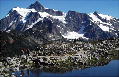


Ben was visiting the Northwest from San Diego again. As before, I arranged for us to climb something together. The visit being somewhat of an annual/bi-annual event for Ben, I was sure he'd appreciate climbing a relatively "classic" route up an undeniably spectacular peak. As such, Mount Shuksan via the Fisher Chimneys fit the bill quite nicely. The weather outlook looked favorable for the weekend and together with Tom we headed over to the Mt. Baker ski area for the short slog over to Lake Ann.

We parked at the upper Mt. Baker ski area parking lot and hiked up the still completely snow covered ski runs to the ridge below Artist's Point (later in the season it is possible to drive to Artist's Point). Looking back, one could see Tomyhoi (left and partially out of view) and the American/Canadian Border Peaks. Mount Baker rose majestically from the other side of the ridge to reveal the rarely seen (by me) Park/Boulder Glaciers.

After a bit of a detour to the highest point on the ridge above Artist's Point, we again figured our bearings and descended down into the Swift Creek headwaters and into the valley below us. We hiked along the valley, generally maintaining a low traverse to the left of the creek until we reached the basin on the opposite side. We angled up and right until we reached the low point on the saddle/cirque above Lake Ann which came into view once on top of the ridge. We were joined by Chris and his dog Max soon after camp was set up. Chris, having climbed the Fisher Chimneys last September, shared some very valuable route information with us. One thing was for sure...there is still a TON of snow up there right now and nobody appears to have ventured beyond Lake Ann yet this season.

We awoke that next morning to complete white-out conditions. Hopeful that the clouds would soon dissipate, Tom, Ben and myself started towards what we thought were the Fisher Chimneys. We carefully climbed up unprotectable 50+ degree slush slopes finished by a stupid dirt/shrub gully until we reached an impasse. To the left: 70+ degree snow slopes that appeared to fall away below our feet and disappear into nothingness. To the left: a steep and uncharted bushwhack through rock bands, short trees and leads who knows where. Directly in front of us: A small rock band topped with a small cornice. We agreed not to proceed any further until the visibility improved. After about a half hour, the visibility only became worse. We called it off and descended the way we came up combining about 3 or 4 tree raps to get down the steep slush safely.

We had clearly gone off route. We basically didn't traverse the slope far enough and missed the entrance to the Fischer Chimneys entirely. The left-most arrow indicates the route I believe we took. The remaining arrows indicate the correct entrance and exit to the Fischer Chimneys. Next attempt - the North Face.

Click here to view photos.
home | email | copyright

All photos and text for sverdina.com are copyright © 2002-2025

It would be very much appreciated if you please ask before copying and/or re-publishing content from any part of these pages. To do so, please click here to send a message via feedback form.

Thank You.

©2025 sverdina.com |