


Mount Garfield - South Route, August 2005 (By Paul Klenke)
 as seen from the Snoqualmie - Lundin Saddle.")
The Hazardous Enigma. Well, not so much anymore. More on that later...
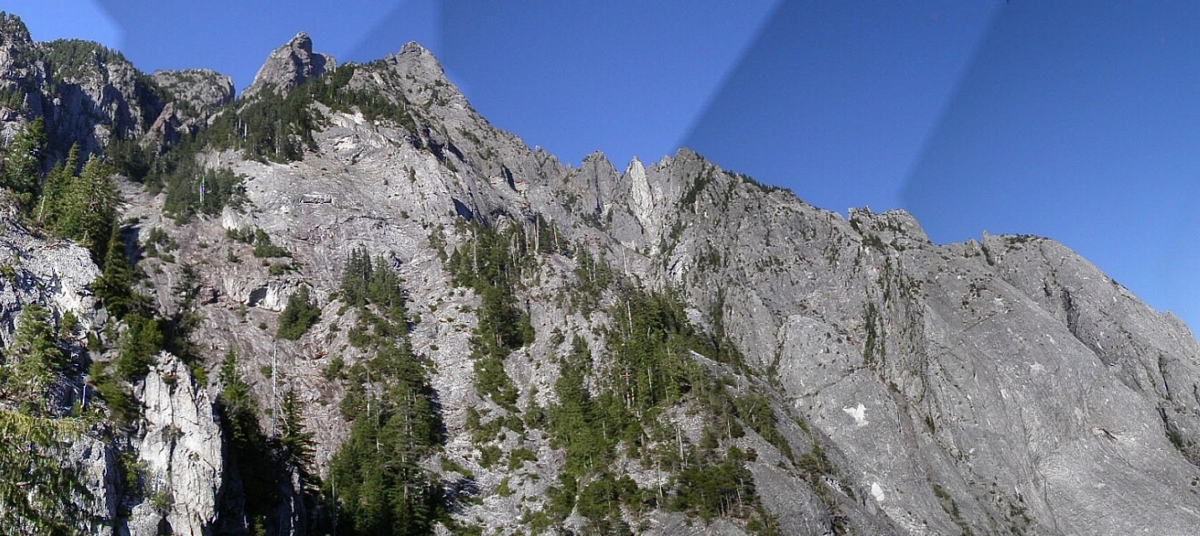
There are lots of "Garfield" named summits in the United States (five Garfield Mountains, seven Garfield Peaks, and four Mt. Garfields). No doubt all of these are named for our 20th President James A. Garfield, who held office for less than one year (1881) before succumbing to a gunshot wound from an assassination attempt. Sixteen peaks in his name is quite an homage. And perhaps the most astonishing peak among all of these is the one in Washington State. Garfield Mountain--more popularly known as Mt. Garfield--is an incredible wave of exposed volcanic rock amidst a sea of lesser, more timbered swells. Because of the extreme amount of exfoliation present on the mountain's complex flanks, it sets itself apart from its neighbors both in visual and in technical appeal. There have been many climbs done on the massif but probably only 5 percent of it has been explored. Just one look at it while climbing it is enough to tell you that. Hopefully, the photos presented here will show you.
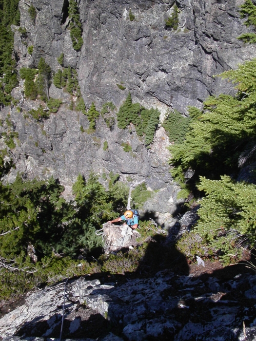
Finally a syzygy of punishment-gluttoners came to pass: Sergio, Eric, and myself. And so it was that we would take on the peak on August 20, 2005. And in the end, for although the climbing was indeed technical and dangerous and we did hazard our rappelling position with rope-induced rock fall, I must say I was disappointed. Why was I disappointed? Read on to find out!
From Interstate 90, take Exit 34 (34 miles east of Seattle) near North Bend. Drive north off the freeway past a truck stop on the left. At the T-junction about 0.5 miles from the freeway take a right onto Lake Dorothy Road. Continue east on this road. It becomes Middle Fork Snoqualmie River Road (FR-56) in a few miles. It is paved for a while then goes to good gravel (recently regraded). At some point on the road you will see your quarry looming in the distance. Then the forest canopy hems in your views. At 14 miles you will come to the Taylor River Road junction. Continue for 2.6 miles past two switchbacks to the trailhead, which is located at a wide gravel wash that you have to descend a few feet to get into. You may also know it by the redneck paraphenalia littered about: old TVs, old CDs used as skeet targets, milk jugs on sticks, and bullet casings on the ground. Hope that when you get back to your car at the end of your climb they haven't used it as a target...."I'll give you $20 if you can shoot out the rearview mirror through the cracked window without breaking the window." "At 50 yards?" "At 50 yards." "You're on." "How many shots do I get?" "As many as you need." "Do you have the semi-automatic with you?" "Sure. I'll just get it..."
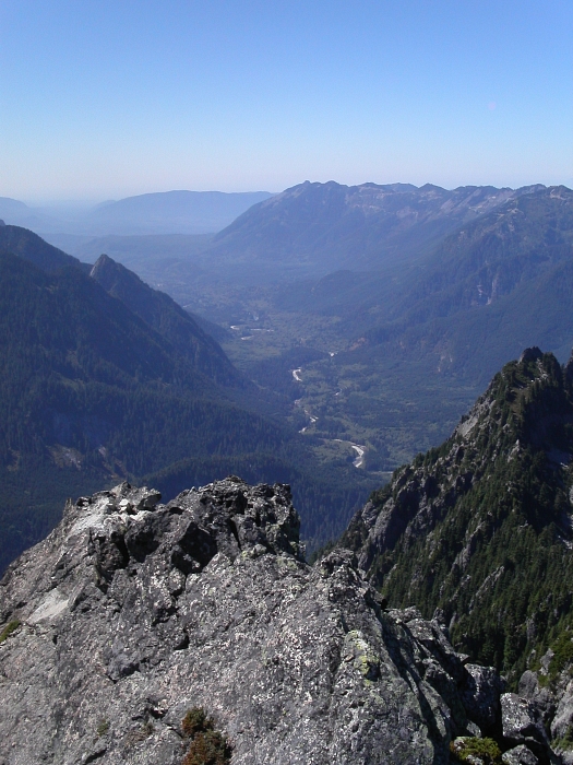
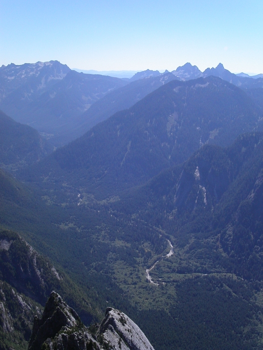
The mountain is located barely 35 miles from Seattle in the Cascades, it lying completely within the Middle Fork Snoqualmie River drainage. At a relatively low height of 5,519 ft the mountain is not easily seen from most distant traditional summits. You have to take to the more obscure climbs such as Preacher Mountain to the south to appreciate it in its full glory. And that's if the weather is cooperating. And, speaking of weather, a climb of Garfield should not be undertaken in anything but dry conditions. All that steep slabbiness would be treacherous if wet, and the steep forest wouldn't be any easier to manage. There are actually five separate peaks on the Garfield Mountain massif and several lesser crags. Every single one of these peaks requires technical climbing to conquer. The West Peak (4896F, 336P) is 0.9 miles away. It's most notable feature is a 20+ pitch sport route bolted onto the slabs of a south side gully/amphitheater. This sport route is called "Infinite Bliss" and has been spotlighted in several climbing magazines. I reserve no judgment here on the permissibility of this 'bolted' route within the Alpine Lakes Wilderness, in which the Garfield Mountain massif resides.
The East Peak (5480+F, 520P) is 0.4 miles away. A worthy objective unto itself, it is largely forgotten. The North Peak (5101F, 301P) is 0.5 miles away. The last peak and perhaps the most astonishing is just west of the Main Peak. It is called Leaning Spire (5040+F, 120P) and it really does lean and it really is a spire. Its east face rises incredibly above the notch separating it from the Main Peak. Two of the lesser crags are Courte-Echelle, the next large tower to the east of the Main Peak, and Little Flat Top, a small horn in between the two. Outrigger Spire (4960+F, 240P) is located north of the East Peak. The first ascent occured in August 1940 when Jim Crooks and Judson Nelson (no, not the actor Judd Nelson) climbed the main summit by the "South Route." Their route may be slightly different than the current South Route. The first fatality came 25 years later in 1965. There have been at least two other fatalities since then. Indeed hazardous. But an enigma? Only if you try a new, as yet unexplored route. Some man named Steve Martin (no, not the comedian/actor Steve Martin) appears in the register at least 10 times in the last 10 years. Some of these ascents were done a mere week apart a couple of years ago? This guy must live close by or have a "one track" mind.
And so I must address the "Hazardous Enigma" label. This was first written by Fred Beckey in his Cascade Alpine Guide in 1973 but I suspect it may be much older than that. Whether or not he coined the words is uncertain. The label is enough to draw many alpine adventurers to its rocky ramparts. And so it was that I was drawn to it but procrastinated on climbing it for well nigh 10 years. What was I waiting for? Weather and partners and agility and fear all conspired against me. There are many "hazardous" peaks and many enigmatic peaks, but how many are both? From the onset we found the route to be well-traveled. In fact, ours was not even the only trio up there that day. There is a discernable bootpath not far from the car. And where this bootpath is hard to track there "is" a veritable line of bright pink flagging to follow. It is only where there is only rock underfoot that the path lacks and the flagging flags. But this is where the cairns pick up the slack. Add to these the usual assortment of rappel anchor slings seemingly all over the place and the anchor chains bolted to slabs and you can see that many have gone to great effort to DUMB DOWN the route for the masses. While I admit I took advantage of being led by the hand by all of the above, I felt I was cheating myself. I was prepared for a forced bivy (Beckey makes good warning of this) but in the end 13 hours is all we needed for the round trip.
And so I made a concerted effort to smarten up all that dumbness by removing as much superflous flagging as I could get my hands on. Sometimes there was even more than one strip of flagging tied to the same branch. As if one bright pink ribbon isn't enough. So, if you're reading this and considering an ascent of the peak by the standard South Route, please leave the flagging at home. Let's try to return some measure of "enigma" to the mountain. The hazardous part is beyond my control. But by showing "the way" to a greater spectrum of climber abilities, all the route markers are in a way mitigating the hazards.
Click here to view photos.
![]()


