Last Updated: November 11, 2024


Start

Recent content updates are viewable under what's new.

Reports in the queue for posting are coming soon!

Upcoming reports & photos:

Oh my! Quite the backlog here...

  • Ben Lomond - scramble (September 2023)
  • Mount Killam (Gambier Island) - hike (September 2023)
  • Lone Goat & Snow Camp Mountain - hike (September 2023)
  • Isollilock Peak - scramble (October 2023)
  • Mount Manson - Mount Hatfield Traverse - scramble (October 2023)
  • The Gargoyles & Columnar Peak - scramble (October 2023)
  • Opal Cone and Lava Glacier - hike (October 2023)
  • Park Butte (WA) - hike (October 2023)
  • Trappers Peak (WA) - scramble (October 2023)
  • Rattlesnake Ledge (WA) - hike (November 2023)
  • Sauk Mountain (WA) - hike (November 2023)
  • Sunshine Coast (Mount Daniel, Pender Hill) - hike (November 2023)
  • Mount Dickerman (WA) - hike (November 2022)
  • Verona Peak AKA Winter's End - snowshoe (November 2023)
  • Dolomites (IT) - snowboard (December 2023)
  • Red Rock Canyon (NV) - scramble (January 2024)
  • Flute Summit & Oboe Summit - snowboard (February 2024)
  • Whistler Miscellaneous (Train Wreck, Loggers Lake, Shadow Lake and more) - hike (February 2024)
  • Mount Underhill - hike (March 2024)
  • Bombtram Mountain - snowshoe (March 2024)
  • Steep Peak - snowboard (March 2024)
  • Ruby Mountain (WA) - snowshoe (April 2024)
  • Blustry Mountain - hike (April 2024)
  • Sowerby Peak (Barr East) - snowshoe (April 2024)
  • Picacho Peak (AZ) - hike (April 2024)
  • Kitt Peak Observatory (AZ) - (April 2024)
  • Mount Wrightson (AZ) - hike (April 2024)
  • Saguaro National Park (AZ) - April 2024)
  • Superstition Peak/Benchmark (AZ) - scramble (April 2024)
  • Mount Humphreys (AZ) - hike (May 2024)
  • Petrified Forest National Park (AZ) - (May 2024)
  • Piestewa Peak (AZ) - hike (May 2024)
  • Channeled Scablands (WA | Columbia Gorge, Ancient Lakes, Potholes Lake, Palouse Falls and more) - hike (May 2024)
  • Rhododendron Mountain ("Pk. 2220") - snowshoe (June 2024)
  • Flora Peak - hike (June 2024)
  • Gibson Peak - snowshoe (June 2024)
  • Mount Urquhart - scramble (June 2024)
  • Rock Mountain (WA) - hike (July 2024)
  • Ladies Pass Quartet (WA | Cape Horn, Ladies Peak, Snowgrass NE Peak, Snowgrass Mountain) - scramble (July 2024)
  • Old Snowy (WA) - scramble (July 2024)
  • Dog Mountain (WA) - hike (July 2024)
  • Mount Ratney & Mount Bardean - scramble (July 2024)
  • Torrent Peak - scramble (July 2024)
  • Steep Peak - Darkside Peak Traverse - scramble (July 2024)
  • Silvertip Mountain - scramble (July 2024)
  • The Old Settler - scramble (July 2024)
  • Silent Hub Peak - scramble (August 2024)
  • Saint Jacobs Mountain - scramble (August 2024)
  • Mount David (WA) - scramble (August 2024)
  • Goat Mountain West Peak & Table Mountain (WA) - hike (August 2024)
  • Griswold Pass (Tuber Hill, Glacier View Peak, Subatomic Peaks: Baryon, Meson, Muon, Lepton) - scramble (September 2024)
  • Yellow Aster Butte (WA) - hike (September 2024)
  • Mazama Dome (WA) - hike (September 2024)
  • Ptarmigan Ridge - (WA | The Portals East Peak, Coleman Pinnacle) - hike (September 2024)
  • Tetrahedron Peak - scramble (September 2024)
  • Lone Cone & Peak 86 (Tofino) - hike (September 2024)
  • Mount Athelstan ("Pk. 2460") - scramble (September 2024)
  • Excelsior Peak and Cowap Peak - hike (October 2024)
  • Hollyburn Peak - hike (October 2024)
  • Cheam Peak - hike (October 2024)
  • Blanchard Needle - scramble (October 2024)
  • Debeck's Hill & 4 Lakes Loop - hike (October 2024)

*As of 11/11/2024


Database

Query the reports database, selecting from criteria which include name, location, type, season etc.

Quick Links

Essential links & whatnot:


Jump To

Select from list below to jump to a specific area on this site.


| Featured Trip Report |


Last Updated: Jul. 30, 2009

Mount Anderson - East Ridge of West Peak (and Mount Anderson proper), July 2009
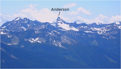


I credit long-time climbing partner Eric H. for initially drawing my attention to Mount Anderson, a large mountain massif hidden deep within the Olympic Mountains. To be honest, it seemed like an unremarkable, out-of-the-way pile representative of most of the peaks in the range. One could say that I wasn't exactly enthusiastic about Anderson. But, alas I promised Eric I'd climb it with him someday if he would accompany me on the West Arete of Mount Constance - a peak he had already visited two times prior. In my ever-expanding quest to visit unclimbed (by me) peaks in unfamiliar (to me) pockets of our local mountain ranges, Anderson's increase in priority on my to-do list was virtually assured. By the summer of 2009 it was finally getting to be time to pull the trigger on the trip. Despite the unfortunate fact that Eric wouldn't be able to join us, Paul K's timely suggestion to climb the peak over the July 4th weekend was music to my ears. *All text from this point on (excluding image captions) by Paul K. and based on his SummitPost page - East Ridge from Flypaper Pass.

Described in this report is the standard route (the only route mentioned in the Olympics guidebook). But whereas the guidebook is sparse (as always) with details, I will fill you in with some. What you need to be prepared for when climbing this peak is loose rock and route finding, particularly in poor (fogged-in) weather. The route is circuitous depending on one's start point. For probability's sake, I'll start the route description from Anderson Pass a couple of miles SSE of the summit. The added attraction of this route is it will take you past the hydrographic apex of the Olympic Range. You can stand at the triple divide point, one of very few in the world. A cadenting sweat bead on your brow could drop into the basin to the south and drain away toward the Pacific Ocean via the Quinault River. Or the bead could drop to the northwest down the north face of the mountain and find its way to the Strait of Juan de Fuca by way of Hayes Creek thence the Elwha River. Or the bead could drop eastward onto the Eel Glacier and slide away to Silt Creek thence the Dosewallips River to the Puget Sound (Hood Canal). Or if you're not careful, you yourself could fall into one of the above, with that cadenting tear replaced by cadenting blood. But enough of the macabre... (more...)

Click here to view photos.
home | email | copyright

All photos and text for sverdina.com are copyright © 2002-2024

It would be very much appreciated if you please ask before copying and/or re-publishing content from any part of these pages. To do so, please click here to send a message via feedback form.

Thank You.

©2024 sverdina.com |