Last Updated: December 4, 2024


Start

Recent content updates are viewable under what's new.

Reports in the queue for posting are coming soon!

Upcoming reports & photos:

Oh my! Quite the backlog here...

  • Isollilock Peak - scramble (October 2023)
  • Mount Manson - Mount Hatfield Traverse - scramble (October 2023)
  • The Gargoyles & Columnar Peak - scramble (October 2023)
  • Opal Cone and Lava Glacier - hike (October 2023)
  • Park Butte (WA) - hike (October 2023)
  • Trappers Peak (WA) - scramble (October 2023)
  • Rattlesnake Ledge (WA) - hike (November 2023)
  • Sauk Mountain (WA) - hike (November 2023)
  • Sunshine Coast (Mount Daniel, Pender Hill) - hike (November 2023)
  • Mount Dickerman (WA) - hike (November 2022)
  • Verona Peak AKA Winter's End - snowshoe (November 2023)
  • Dolomites (IT) - snowboard (December 2023)
  • Red Rock Canyon (NV) - scramble (January 2024)
  • Flute Summit & Oboe Summit - snowboard (February 2024)
  • Whistler Miscellaneous (Train Wreck, Loggers Lake, Shadow Lake and more) - hike (February 2024)
  • Mount Underhill - hike (March 2024)
  • Bombtram Mountain - snowshoe (March 2024)
  • Steep Peak - snowboard (March 2024)
  • Ruby Mountain (WA) - snowshoe (April 2024)
  • Blustry Mountain - hike (April 2024)
  • Sowerby Peak (Barr East) - snowshoe (April 2024)
  • Picacho Peak (AZ) - hike (April 2024)
  • Kitt Peak Observatory (AZ) - (April 2024)
  • Mount Wrightson (AZ) - hike (April 2024)
  • Saguaro National Park (AZ) - April 2024)
  • Superstition Peak/Benchmark (AZ) - scramble (April 2024)
  • Mount Humphreys (AZ) - hike (May 2024)
  • Petrified Forest National Park (AZ) - (May 2024)
  • Piestewa Peak (AZ) - hike (May 2024)
  • Channeled Scablands (WA | Columbia Gorge, Ancient Lakes, Potholes Lake, Palouse Falls and more) - hike (May 2024)
  • Rhododendron Mountain ("Pk. 2220") - snowshoe (June 2024)
  • Flora Peak - hike (June 2024)
  • Gibson Peak - snowshoe (June 2024)
  • Mount Urquhart - scramble (June 2024)
  • Rock Mountain (WA) - hike (July 2024)
  • Ladies Pass Quartet (WA | Cape Horn, Ladies Peak, Snowgrass NE Peak, Snowgrass Mountain) - scramble (July 2024)
  • Old Snowy (WA) - scramble (July 2024)
  • Dog Mountain (WA) - hike (July 2024)
  • Mount Ratney & Mount Bardean - scramble (July 2024)
  • Torrent Peak - scramble (July 2024)
  • Steep Peak - Darkside Peak Traverse - scramble (July 2024)
  • Silvertip Mountain - scramble (July 2024)
  • The Old Settler - scramble (July 2024)
  • Silent Hub Peak - scramble (August 2024)
  • Saint Jacobs Mountain - scramble (August 2024)
  • Mount David (WA) - scramble (August 2024)
  • Goat Mountain West Peak & Table Mountain (WA) - hike (August 2024)
  • Griswold Pass (Tuber Hill, Glacier View Peak, Subatomic Peaks: Baryon, Meson, Muon, Lepton) - scramble (September 2024)
  • Yellow Aster Butte (WA) - hike (September 2024)
  • Mazama Dome (WA) - hike (September 2024)
  • Ptarmigan Ridge - (WA | The Portals East Peak, Coleman Pinnacle) - hike (September 2024)
  • Tetrahedron Peak - scramble (September 2024)
  • Lone Cone & Peak 86 (Tofino) - hike (September 2024)
  • Mount Athelstan ("Pk. 2460") - scramble (September 2024)
  • Excelsior Peak and Cowap Peak (WA) - hike (October 2024)
  • Hollyburn Peak - hike (October 2024)
  • Cheam Peak - hike (October 2024)
  • Blanchard Needle - scramble (October 2024)
  • Debeck's Hill & 4 Lakes Loop - hike (October 2024)
  • Mount Hallowell - hike (November 2024)
  • Anderson Mountain (WA) - hike (December 2024)
  • Sumas Mountain (WA) - hike (December 2024)

*As of 12/04/2024


Database

Query the reports database, selecting from criteria which include name, location, type, season etc.

Quick Links

Essential links & whatnot:


Jump To

Select from list below to jump to a specific area on this site.


| Featured Trip Report |


Last Updated: May 10, 2006

Bedal Peak - Northwest Ridge (attempt), April 2006
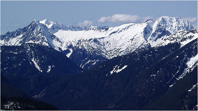


I originally intended not to post this report, but I can't seem to help myself. In any case, though the ski descent proved to be a disappointment, the beautiful weather and views of peaks still firmly in the grip of Winter proved worthy of sharing. Not to mislead anyone - I'm sure the ski descent of Bedal's North Slope (as we'd intended) would be a fine outing. Certainly Paul Klenke's March '06 post on CC.com revealed the obvious ski-descent potential of the North Slope. As a matter of fact, Paul's vivid photos are what first lured me to attempt the peak.

Anyway, my powers of persuasion must be good, for I managed to convince Eric Houtkooper Jerry S. and Cosmo (Jerry's dog) into joining me. Approaching from north on the MLH, we took a left onto FR-4096 (not shown on the USGS map). Based on Paul's information, we stopped a few hundred yards before the second switchback where a boot path cuts left into the woods (c. 2,100 ft near Merry Brook). The path was promptly lost, after which an annoying ascending thrash-traverse was endured before encountering small boulder slopes in the forest and the first patches of snow. Turning uphill, we booted up the snowy forest to reach a minor ridge crest overlooking Nels Lake (which we never saw). Donning our skis here, we continued up along the ridge eventually reaching a small, but aesthetic basin with steep cliffs ringing its left side. Dropping left a bit off of the ridge, I continued into the basin and on up towards its apex. A short, but steep headwall of powder snow overlying frozen avalanche debris proved most annoying and exhausting to surmount, but we soon found ourselves at a saddle, high on Bedal's craggy Northwest Ridge. From the saddle, steep, exposed snow led right around a corner with a short but unappealing snow gully with rock constriction seemingly providing the only exit onto the North Slope above. Hmm...it was supposed to be much easier than this.

Stymied by the unexpected problem and with only one ice axe between the three of us, we were effectively stuffed. Also, without a leash to secure Cosmo, there was also no way to carry him or keep him from falling down towards Bedal Creek Valley should he lose his footing. Sure, all these factors weighed on me...and add to that the fact that we were clearly off-route and I had lost my motivation to continue. BBQ and beers were calling. Traversing back left onto the ridge we followed earlier, we continued down through icy forest and descended a large clearing for several hundred feet before running out of snow. Soon finding the trail, we were able to follow it most of the way back to the Subi. So, where did we go wrong? Best guess is that we followed that forested ridge a bit too long and should have traversed left above Nels Lake much sooner.

Click here for photos.
home | email | copyright

All photos and text for sverdina.com are copyright © 2002-2024

It would be very much appreciated if you please ask before copying and/or re-publishing content from any part of these pages. To do so, please click here to send a message via feedback form.

Thank You.

©2024 sverdina.com |