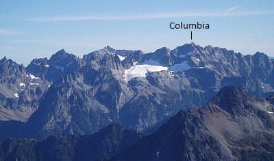
Columbia Peak - West Spur, October 2004

After years of living vicariously through Phil's Fortier's trip reports, it felt a little weird at first to actually be accompanying him on a climb. I had previously wondered if we would ever cross paths in the mountains somewhere. A chance encounter last spring when both Phil and Dave Burdick were thumbing for a ride on hwy20 following a ski on Mt. Hardy put that question to rest. It's funny how one can recognize someone via their presence on the internet, without actually "knowing" that person. Our outing on Columbia Peak was the result of Phil's CascadeClimbers.com posting in the partners forum. With the nice weather we were having during the week forecasted to deteriorate by the weekend, we apparently both felt the need to run to the hills for what could very well be the final dose of fall sunshine. Conditions seemed a bit marginal for a backcountry ski, so we opted for a scramble of some sort. With Phil's hand being injured following an avalanche incident on Rainier's Flett Glacier this September, significant amounts of belaying or pulling on rock were out of the question. "How about Columbia?" asked Phil. "Uhh, sure," I replied, and with that the matter was resolved. Now, if only they could accurately predict the weather...
We arrived at Barlow Pass to be greeted by a heavy mist. Surely it'll burn off. Right? Removing my bike from the bed of Phil's truck, I prepared, as I have so many times before, for that chilly, early morning bike ride to Monte Cristo. With much to talk about, the four miles passed by quickly. Before long, we had stashed our bikes and were hiking up the Silver Lake Trail to Poodle Dog Pass. It seemed the higher we went, the wetter it got, and by the time we reached Poodle Dog Pass it was positively raining. Motivated to not let this day-a day we both took off from work-go to waste, we pressed on.
We followed a worn path that branches off left from the pass. Ignoring the occasional spur, we followed the path as it first descended to a timbered saddle and then traversed the right side of a brushy hillside. Already my pants and boots were completely soaked from brushing up against the moisture-laden vegetation lining the path, but at least the rain had stopped now. The path eventually gains the E-W ridge crest and follows it a short distance before descending talus on its left side. We then traversed the left (north) side of the ridge, following bits of trail through talus and heather to reach the toe of the West Spur. Turning left, we continued on good trail up the spur and into the mist. The trail traverses the right side of the spur a short distance, ending at a sandy bench, whereupon we cut back up left to re-gain the crest. Stopping at a flattish heather area beneath a steep rock nose, we stopped for lunch. Resting on a nearby boulder I found an Italian Euro coin with business card laying beneath it. Maurizio from Firenze I believe it was...it appears I'm not the first Italian to have climbed Columbia.
Working left of the nose, a small ice patch led to a short but loose class-4 rock step with a talus slope above. The fog moved in and out, providing only momentary glimpses of the '76 Glacier off to our left. We worked our way up into what appeared to be a small amphitheater and swung left around a corner to see if it would go. Traversing below a vertical wall, a flat ledge about 6 feet wide mysteriously disappeared into the mist. Looking over the foggy edge, one could only guess at how many vertical feet the edge of this ledge falls away to the '76 Glacier below. It felt as if this were an appropriate spot for filming a scene for the Lord of the Rings trilogy. Unable to reconcile what we saw there with the Beckey route description, we looked elsewhere for alternatives. A short ramp just right of this corner looked reasonable...in dry conditions. While I was contemplating the funky move required to surmount the blocks near the top of this ramp, Phil traversed to the amphitheater's right side and discovered easy scrambling above and around the right corner. I down-climbed the ramp and followed his lead.
Once around the corner, we walked onto a large, sloping bench. With the bench terminating in the craggy wall of the South Ridge, we looked up and left for a continuation. After a wet, awkward class-4 step, we scrambled up mostly 3rd-class terrain to once again gain the gravelly crest of the West Spur. With occasional delicate moves on rotten rock, we followed the path of least resistance on the right side of the crest to reach a small notch directly beneath the summit. From the notch, we traversed a thin and exposed ledge on the left side of the summit block. Acutely aware that a single slip would have disastrous consequences, I deliberately edged my way across those final feet of the wet "ledge". Once across, we worked up a small sand/mud gully and cautiously scrambled the remaining ground to the summit. Views were non-existent and with the wind and rain now picking up again, we quickly signed the summit register, congratulated each other, and got the hell out of there.
Carefully retracing our route, we descended the West Spur without incident and made it back to Monte Cristo in good time. Barreling down that gravel road on a bike is always a blast...providing that oncoming traffic doesn't send you careening off the road!
Click here to view photos.


