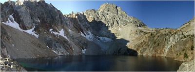
Thompson Peak - South Coulior, October 2010

Easily identified from downtown Stanley, Thompson Peak is the highest summit in the Sawtooth Range. At 10,751-ft, Thompson offers unobstructed views of the broad valleys that define the northern and eastern boundaries of the Sawtooth National Recreation Area, not to mention the bulk of the Sawtooth Range immediately to the south. The approach features a pleasant albeit long approach (~6.5 miles) with a remote feel that requires somewhat more routefinding skill than Mount Regan to the northwest.
Following a climber's trail that all but disappears once the basin between Mount Williamson and Mount Thompson is reached, one is left to follow his/her nose on a cross-country trek, up and over a high alpine saddle and around the south side of the peak seemingly into the unknown. A most tedious talus slope guards the final exit via the standard South Coulior route, and deposits one at the base of a short, but steep and exposed summit ridge. The final moves definitely get the blood pumping and make for a fitting finish to what amounts to a great day in the mountains!
With a pre-dawn start, I made my way over to the trailhead at the backpackers parking lot and followed Fishhook Creek Trail for about .8 miles to a signed junction (the sign indicates Marshall lake). Continuing on, the trail passes through a grove of aspens and makes for a vibrant burst of color this time of year. I reached a forested ridge top a short distance beyond the turning aspens, then turned left and followed the trail for a few miles passing a wilderness boundary sign along the way. Taking a left at a faint trail spur, I proceeded on a loose sidehilling traverse towards a large alpine basin below the base of Mount Williamson.
The trail vanishes upon reaching the hanging meadow in the basin surounded by Williamson at right and Thompson in front. Continuing up the meadow, I soon reached a beautiful high alpine lake at ~9000ft and tucked away right at base of Thompson and Mickey Spire (to the left). From the lake the objective is to gain the headwall at the Saddle between Thompson and Williamson (as seen at left), crossing numerous small talus basins along the way. Staying left as I approached the headwall I easily located a breach in the wall allowing me to scramble up to the saddle with little difficulty. From the saddle, I traversed up and around the west side of peak onto a seemingly endless and most annoying scree and talus slope which I followed around the south-side of the peak close to the Saddle between Thompson and Mickey Spire.
Looking up, I soon noticed an obvious gully that would deliver me to the final summit ridge crest. There was a short bit of class 3 scrambling here, and perhaps a couple 4-ish moves with exposure just before the summit proper. The views from Thompson are outstanding! The alpine lake mentioned previously almost looks like a crater from this vantage point. Looking to the NE towards Stanley and beyond gives one an appreciation for the relief these mountains have.
And that sums up my adventure in the Sawtooths folks. I had originally intended to bag one last peak on this trip - Baron Peak perhaps, but I've spent so much time doing this sort of thing lately that it was beginning to feel a bit like drudgery by now. Not only that, but I really needed to get a job once and for all. That being said, I'm definitely making another trip out here to tick off some of the more classic routes. But first I need to start accruing some vacation again!
Click here to view photos.


