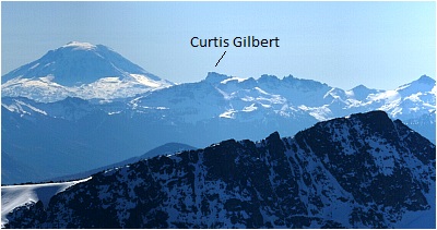
Mount Curtis Gilbert - Conrad/Meade Glacier, November 2004

I first spied the Goat Rocks from the southwestern flanks of Mount Rainier during my early attempts at climbing that pesky volcano. Probably the most rugged and certainly the tallest and most interesting of the high peaks of the Southern Cascades (actual Volcanoes excluded), the Goat Rocks tend to be overlooked for the more obvious peaks in the area - Rainier, Adams and Saint Helens. However, the Goats tower above the densely timbered hills that constitute the majority of the Southern Cascades and as such beckon the Cascades peakbagger to come in for a closer look. Future views of the range from Castle Saddle (Tatoosh Range) and most recently from the northern slopes of Mount Adams rekindled my desire to visit this remote area. I easily sold the idea to Eric Hoffman, Eric Houtkooper (Hoochie ~ as we called him back at WSU) and Jerry Sanchez...what better opportunity than to spend a sunny November weekend in the Goats? Our objective you ask? Why the tallest peak in the range of course - Mt. Curtis Gilbert (8,184 ft). Our route? The Conrad Glacier; and we'd do it on skis/split to boot! Um, well, sort of...
We started at the Conrad Meadows trailhead. The approach is a mind-numbing valley slog for most of the 8 miles to camp. It was easily the farthest I have gone with skis (plus overnight gear) on my back. Surely we would be skinning within a couple miles of the trailhead right? Not so! At best, we skinned maybe the last mile to camp. No doubt a reminder that it is still very much autumn and not winter yet! Despite the trivialities of the approach, there are at least two suggestions I'd offer any prospective party. First, at a faint fork in the trail about two miles in, take the "un-maintained" uphill (right) fork, else you will find yourself running laps on the Surprise Lake Loop! The correct trail traverses a minor forested ridge and descends to the Conrad Creek Valley for several more miles of uninteresting forest and meadow walking. We eventually lost the trail at a marshy meadow, and blindly plowed ahead through slushy mud to reach open forest, and the trail, at the opposite end of the meadow. A wise alternative would be to crash through dense forest skirting the right edge of the marsh. While doing this, look for a trail continuation which climbs up around the fallen trees down low and avoids the marsh entirely. (more...)
Click here to view photos.


