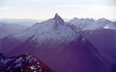
Sloan Peak - West Face Corkscrew Route, August 2003

Ever since my Sloan Glacier reconnaissance trip in the spring of 2000, featuring the heart-stopping frigid N. Fork Sauk River ford, I've wanted to venture back to the area and bag the summit of Sloan Peak. Originally planning on climbing the Sloan Glacier/Corkscrew Route, my mind was changed last season by a posting on CascadeClimbers.com that said simply "Sloan Glacier = Slog, Rock = Fun." By "rock", I understood the poster to be referring to the routes on Sloan's impressive West and Southwest Faces. The 2002 summer climbing season came and went and, for various reasons, I never made it out to Sloan Peak. Then, in August of 2003 Mike Stanton and Theron Welch climbed the West Face and posted a trip report to show their efforts. The temptation was too much. Armed with Beckey's route description and Stanton's report, John Mefford and I set out to climb the West Face ourselves.
The Bedal Creek Trail approach is short (3 miles?), and alternates through open forest and damp patches of dense brush (the kind that obscures the trail underfoot). The trail eventually ends at a dry creek bed. We followed the occasional cairn for a short distance up the creek bed before tiring of boulder-hopping and instead sought a trail continuation on the left side of the bank. A faint trail and some orange flagging seemed to suggest we were headed in the correct direction (continuing up the creek bed a while longer, the main trail resumes again on the right bankâ¦look for cairns). We exited the trees at the far left side of Bedal Basin, the sheer Northwest Face of Sloan Peak rising mostly in front and right of us. Angling to the right, we traversed heather then made a rising traverse on the talus slope that fans out below Sloan Peak's Northwest Face. At the far right of this talus slope we descended a short distance into a loose gully, which we then climbed up as the West Face began to tower above us. Rather than getting suckered into the gully, a better way might be to continue traversing beneath the West Face, aiming for a prominent rib that extends from ledges on the West Face. This rib becomes the lightly timbered and grassy ridge that defines the southwestern perimeter of Bedal Basin (following the trail on the right side of the previously mentioned creek bed would lead one straight to this rib). Ideally, one would want to hike to the crest of this rib and begin climbing towards prominent ledges that break the West Face. (more...)
Click here to view photos.


