Last Updated: November 28, 2024


Start

Recent content updates are viewable under what's new.

Reports in the queue for posting are coming soon!

Upcoming reports & photos:

Oh my! Quite the backlog here...

  • Lone Goat & Snow Camp Mountain - hike (September 2023)
  • Isollilock Peak - scramble (October 2023)
  • Mount Manson - Mount Hatfield Traverse - scramble (October 2023)
  • The Gargoyles & Columnar Peak - scramble (October 2023)
  • Opal Cone and Lava Glacier - hike (October 2023)
  • Park Butte (WA) - hike (October 2023)
  • Trappers Peak (WA) - scramble (October 2023)
  • Rattlesnake Ledge (WA) - hike (November 2023)
  • Sauk Mountain (WA) - hike (November 2023)
  • Sunshine Coast (Mount Daniel, Pender Hill) - hike (November 2023)
  • Mount Dickerman (WA) - hike (November 2022)
  • Verona Peak AKA Winter's End - snowshoe (November 2023)
  • Dolomites (IT) - snowboard (December 2023)
  • Red Rock Canyon (NV) - scramble (January 2024)
  • Flute Summit & Oboe Summit - snowboard (February 2024)
  • Whistler Miscellaneous (Train Wreck, Loggers Lake, Shadow Lake and more) - hike (February 2024)
  • Mount Underhill - hike (March 2024)
  • Bombtram Mountain - snowshoe (March 2024)
  • Steep Peak - snowboard (March 2024)
  • Ruby Mountain (WA) - snowshoe (April 2024)
  • Blustry Mountain - hike (April 2024)
  • Sowerby Peak (Barr East) - snowshoe (April 2024)
  • Picacho Peak (AZ) - hike (April 2024)
  • Kitt Peak Observatory (AZ) - (April 2024)
  • Mount Wrightson (AZ) - hike (April 2024)
  • Saguaro National Park (AZ) - April 2024)
  • Superstition Peak/Benchmark (AZ) - scramble (April 2024)
  • Mount Humphreys (AZ) - hike (May 2024)
  • Petrified Forest National Park (AZ) - (May 2024)
  • Piestewa Peak (AZ) - hike (May 2024)
  • Channeled Scablands (WA | Columbia Gorge, Ancient Lakes, Potholes Lake, Palouse Falls and more) - hike (May 2024)
  • Rhododendron Mountain ("Pk. 2220") - snowshoe (June 2024)
  • Flora Peak - hike (June 2024)
  • Gibson Peak - snowshoe (June 2024)
  • Mount Urquhart - scramble (June 2024)
  • Rock Mountain (WA) - hike (July 2024)
  • Ladies Pass Quartet (WA | Cape Horn, Ladies Peak, Snowgrass NE Peak, Snowgrass Mountain) - scramble (July 2024)
  • Old Snowy (WA) - scramble (July 2024)
  • Dog Mountain (WA) - hike (July 2024)
  • Mount Ratney & Mount Bardean - scramble (July 2024)
  • Torrent Peak - scramble (July 2024)
  • Steep Peak - Darkside Peak Traverse - scramble (July 2024)
  • Silvertip Mountain - scramble (July 2024)
  • The Old Settler - scramble (July 2024)
  • Silent Hub Peak - scramble (August 2024)
  • Saint Jacobs Mountain - scramble (August 2024)
  • Mount David (WA) - scramble (August 2024)
  • Goat Mountain West Peak & Table Mountain (WA) - hike (August 2024)
  • Griswold Pass (Tuber Hill, Glacier View Peak, Subatomic Peaks: Baryon, Meson, Muon, Lepton) - scramble (September 2024)
  • Yellow Aster Butte (WA) - hike (September 2024)
  • Mazama Dome (WA) - hike (September 2024)
  • Ptarmigan Ridge - (WA | The Portals East Peak, Coleman Pinnacle) - hike (September 2024)
  • Tetrahedron Peak - scramble (September 2024)
  • Lone Cone & Peak 86 (Tofino) - hike (September 2024)
  • Mount Athelstan ("Pk. 2460") - scramble (September 2024)
  • Excelsior Peak and Cowap Peak (WA) - hike (October 2024)
  • Hollyburn Peak - hike (October 2024)
  • Cheam Peak - hike (October 2024)
  • Blanchard Needle - scramble (October 2024)
  • Debeck's Hill & 4 Lakes Loop - hike (October 2024)
  • Mount Hallowell - hike (November 2024)
  • Anderson Mountain (WA) - hike (December 2024)

*As of 12/02/2024


Database

Query the reports database, selecting from criteria which include name, location, type, season etc.

Quick Links

Essential links & whatnot:


Jump To

Select from list below to jump to a specific area on this site.


| Latest Posts |


Monday, August 29, 2022

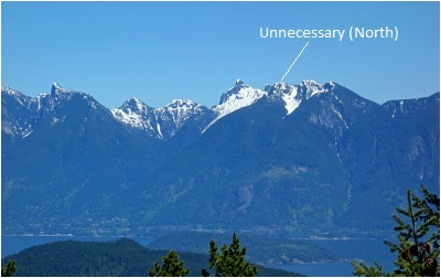
Unnecessary Mountain - via Lions Bay, October 2021


This is a peak I've left for when I can't think of anything else better to do. Ya know, one of those close-to-home, marginal weather, shoulder season kinda objectives. It's also one that I've attempted twice previously, first on my January birthday via Saint Marks only to be stymied by dust-on-ice conditions on the descent to the intervening saddle. Without crampons or an ice axe to stop an uncontrolled slide, I called it up on Saint Marks and wandered about the summit area finally ticking off the somewhat obscure "true" summit and savoring the excellent views from the usual lookout spots. For my next attempt, I set out the following Spring via the steep but shorter trail from Lions Bay. Here again, challenging breakable crust snow conditions significantly slowed my progress and made for a somewhat treacherous hike back down from my turnaround point. Then finally, back at it again in October, once more via Lions Bay for the win!

As stated, it's a steep but good trail that leads directly to the summit of North Unnecessary, complete with some fun scrambly steps mixed in there for good measure. Low clouds and fog meant views were non-existent from the summit, but thankfully just below the cloud ceiling the usual Howe Sound view revealed itself to me. Slightly higher South Unnecessary was just a stone's throw away but going there clearly offered no better views than from the north peak and so I didn't bother. Encountered just one other soul hiking up shortly after commencing my descent, otherwise just me and my thoughts in the fog up there. Good to finally tick this one off the list!

Click here to view.

Saturday, August 13, 2022

Stoyoma Mountain - East Route, September 2021


In the far northern reaches of the Cascade Mountains lies a group of alpine peaks rising from the forested mountains that dominate this part of the range. The highest of these is 7437-ft Stoyoma Mountain, a prominence generally considered to be the "last big mountain in the North Cascades." At risk of overusing the term, the peak is like an island in the sky, without much nearby to block the expansive 360-degree summit views. With nothing but rolling bumps to the east and north, an array of peaks in the Cascade Range far to the south and most notably the glaciated giants flanking the west side of the Fraser Canyon, the perspective is unique and for me a big part of the appeal. For those based in Vancouver, Stoyoma is unfortunately also an objective where the time spent driving there and back greatly exceeds that spent hiking. All I can say to that is at least this was before gas prices hit the Stratosphere!

Turning off Hwy 8 at Petit Creek west of Merritt, I proceeded up the Spius Creek FSR for what seemed like an eternity before reaching the fork that leads up to Cabin Lake. All smooth gravel to this point and against my better judgement I decided to turn up this very rough fork trying to get as close as possible to the trailhead. Sure enough, the tire pressure light flicked on shortly before I parked the truck. Gave it a bit of time to see how bad the leak was but couldn't make out which tire was affected and figured it wasn't anything that needed immediate attention. So off I go for Stoyama, following a path of sorts, then losing it on a short descent through trees to reach a wide basin below the peak's east facing slopes. Then up, over heather, scree and finally a bit of talus to reach a prominent saddle in the north-south running ridge. Turned right here and finished with an easy hike to the summit proper, no more than two hours from where I parked. Great views as mentioned, with the ring of connecting ridges and peaks to the immediate west almost looking like a crater. Neat to see.

I still had time to burn but didn't fancy the long trek out to tag Stoyoma's Widow, so decided to go back and check on the truck instead and if all was well proceed to Cabin Lake and perhaps see if I could locate the wreckage of a Douglas A-26C that went down in the area back in '74. Back to the truck in no time, where the tires still looked okay. Phew! Okay, onwards on foot to Cabin Lake, smartly deciding not to push my luck any further. Pretty little lake with some picnic benches and such, and just one other vehicle parked. Wasn't obvious which way the wreckage was and with a long drive still ahead of me I decided to call it a day and head back. Alas, my luck finally ran out not five minutes down that rough ass road now with a hissing and rapidly deflating tire. To make matters worse, try as I might I simply could not loosen the lug nuts as the shitty OEM lug wrench was stripped. Fuck! With no alternatives, I limped back down to the main FSR and figured I'd drive slowly for as long as possible in hopes of running into someone that could help. Fortunately, it wasn't long before the jeep which was parked at the lake came up behind me, the driver of which being prepared for BC backroads graciously helped me remove and replace the flat. Pleasant fellow, we'd bump into each other again randomly at the Camelshoof Peak trailhead some nine months later. But anyway, can't thank you enough for saving my ass! Till we meet again friend...

Click here to view.
home | email | copyright

All photos and text for sverdina.com are copyright © 2002-2024

It would be very much appreciated if you please ask before copying and/or re-publishing content from any part of these pages. To do so, please click here to send a message via feedback form.

Thank You.

©2024 sverdina.com |