Last Updated: December 14, 2024


Start

Recent content updates are viewable under what's new.

Reports in the queue for posting are coming soon!

Upcoming reports & photos:

Oh my! Quite the backlog here...

  • Mount Manson - Mount Hatfield Traverse - scramble (October 2023)
  • The Gargoyles & Columnar Peak - scramble (October 2023)
  • Opal Cone and Lava Glacier - hike (October 2023)
  • Park Butte (WA) - hike (October 2023)
  • Trappers Peak (WA) - scramble (October 2023)
  • Rattlesnake Ledge (WA) - hike (November 2023)
  • Sauk Mountain (WA) - hike (November 2023)
  • Sunshine Coast (Mount Daniel, Pender Hill) - hike (November 2023)
  • Mount Dickerman (WA) - hike (November 2022)
  • Verona Peak AKA Winter's End - snowshoe (November 2023)
  • Dolomites (IT) - snowboard (December 2023)
  • Red Rock Canyon (NV) - scramble (January 2024)
  • Flute Summit & Oboe Summit - snowboard (February 2024)
  • Whistler Miscellaneous (Train Wreck, Loggers Lake, Shadow Lake and more) - hike (February 2024)
  • Mount Underhill - hike (March 2024)
  • Bombtram Mountain - snowshoe (March 2024)
  • Steep Peak - snowboard (March 2024)
  • Ruby Mountain (WA) - snowshoe (April 2024)
  • Blustry Mountain - hike (April 2024)
  • Sowerby Peak (Barr East) - snowshoe (April 2024)
  • Picacho Peak (AZ) - hike (April 2024)
  • Kitt Peak Observatory (AZ) - (April 2024)
  • Mount Wrightson (AZ) - hike (April 2024)
  • Saguaro National Park (AZ) - April 2024)
  • Superstition Peak/Benchmark (AZ) - scramble (April 2024)
  • Mount Humphreys (AZ) - hike (May 2024)
  • Petrified Forest National Park (AZ) - (May 2024)
  • Piestewa Peak (AZ) - hike (May 2024)
  • Channeled Scablands (WA | Columbia Gorge, Ancient Lakes, Potholes Lake, Palouse Falls and more) - hike (May 2024)
  • Rhododendron Mountain ("Pk. 2220") - snowshoe (June 2024)
  • Flora Peak - hike (June 2024)
  • Gibson Peak - snowshoe (June 2024)
  • Mount Urquhart - scramble (June 2024)
  • Rock Mountain (WA) - hike (July 2024)
  • Ladies Pass Quartet (WA | Cape Horn, Ladies Peak, Snowgrass NE Peak, Snowgrass Mountain) - scramble (July 2024)
  • Old Snowy (WA) - scramble (July 2024)
  • Dog Mountain (WA) - hike (July 2024)
  • Mount Ratney & Mount Bardean - scramble (July 2024)
  • Torrent Peak - scramble (July 2024)
  • Steep Peak - Darkside Peak Traverse - scramble (July 2024)
  • Silvertip Mountain - scramble (July 2024)
  • The Old Settler - scramble (July 2024)
  • Silent Hub Peak - scramble (August 2024)
  • Saint Jacobs Mountain - scramble (August 2024)
  • Mount David (WA) - scramble (August 2024)
  • Goat Mountain West Peak & Table Mountain (WA) - hike (August 2024)
  • Griswold Pass (Tuber Hill, Glacier View Peak, Subatomic Peaks: Baryon, Meson, Muon, Lepton) - scramble (September 2024)
  • Yellow Aster Butte (WA) - hike (September 2024)
  • Mazama Dome (WA) - hike (September 2024)
  • Ptarmigan Ridge - (WA | The Portals East Peak, Coleman Pinnacle) - hike (September 2024)
  • Tetrahedron Peak - scramble (September 2024)
  • Lone Cone & Peak 86 (Tofino) - hike (September 2024)
  • Mount Athelstan ("Pk. 2460") - scramble (September 2024)
  • Excelsior Peak and Cowap Peak (WA) - hike (October 2024)
  • Hollyburn Peak - hike (October 2024)
  • Cheam Peak - hike (October 2024)
  • Blanchard Needle - scramble (October 2024)
  • Debeck's Hill & 4 Lakes Loop - hike (October 2024)
  • Mount Hallowell - hike (November 2024)
  • Anderson Mountain (WA) - hike (December 2024)
  • Sumas Mountain (WA) - hike (December 2024)

*As of 12/04/2024


Database

Query the reports database, selecting from criteria which include name, location, type, season etc.

Quick Links

Essential links & whatnot:


Jump To

Select from list below to jump to a specific area on this site.


| Latest Posts |


Friday, August 25, 2023

Mount Sheer (& Ben More) - Southwest Ridge, August 2022
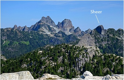


Spent a couple days in the Mountain Lake area, long a place I've wanted to visit, camp at hut, bag peaks etc. Relatively close to home, drive wise, but definitely a sense of being out there. So cool to have this in the "backyard"!

First overnighter for me in ages. No key to ulock gate, so took bike but with the added weight on my shoulders and steepness, it wasn't till about the 5.5 km mark where it wasn't constant on again off again hike-a-bike. Some confusion with the FSR junctions after the 3-way there with the Beth Lake fork, but common sense prevailed and I got to the trailhead after a good 2.5 hrs of sweating. Trail is easy to follow and seems to have been maintained recently, bit overgrown here and there but pretty good all things considered. Hot ass grunt up the south facing switchbacks before reaching the granite and lakes wonderland up there. 6 sweaty hours to hut, whereupon the first bugs of the day were encountered. Note that it had rained the night before, so bugs were still a bit subdued for the time being at least.

Chatted with a group of teens there at hut before dumping gear and heading off for Sheer. Took "high" route there an low route back, lotsa route finding and some exposure. Neat little scramble once on route! About 1:15 to summit from hut. Pretty damn buggy after returning to hut and for the rest of my time up on the plateau. Had designs on Ben Lomond the following day, but ended up on Ben More after dropping gear at Wind Lake instead. Got to the first talus bowl, said f'k that and figured it be better to get up on the ridge and follow that to BL. Did that and got a good look at all the ups n' downs in the way and said meh, not necessary, plus the bugs were starting to get to me. A Ben is better than no Ben's I say.

Back to bike and 30 mins later back to cold beer at car. Those were some smokin' brake rotors I tell ya!

Click here to view.

Thursday, August 10, 2023

Shulaps Peak - via Brett Creek Trail, August 2022


Not a lot of reports from out here, so sharing some info for those who might be curious. Car camped the night before at the free rec. site there below Terzaghi Dam. No bugs...sweet! Up 'n at em the next morning, Marshal Lake Road good for any vehicle. Decided against committing to the spur that reaches the upper trailhead as the truck is in the shop (seized differential) and there's zero forgiveness for pinstriping my wife's fancy SUV. Lower trailhead is a bit obscure but starts at the road bend where there's a white sign that reads Brett Creek Meadows. Adds a nominal amount of vert and distance, but oddly enough is the steepest part of the trail.

Great trail up to alpine, popular with the MTB crowd (Brett Creek Trail). About 1:40 to the equestrian cabin up there. Continued past cabin, now cross country into the large drainage SE of the peak. Pleasant hike through meadows, then turned up the talus apron that lies below a stream/waterfall descending from the enormous talus & scree bowl above. Endless plod up to a saddle in the ridge, with just a couple easily avoidable snow patches. Then finally up the ridge for a longer than expected scramble to summit. No real hands-on action unless you go looking for it. Just under 4 hrs to summit and about 5900ft gain not including all the little ups 'n downs. Comfortable temps and plenty of water sources on route. A worthy trip IMO, cool to see a different corner of range!

Bugs & other critters: none until the meadows beyond the cabin, but nothing noteworthy and then just the pesky horse fly as you go higher. Surprising! Didn't encounter a soul until returning to cabin, where there now were humans with their horses and bikes (jealous). There apparently was a griz in the meadow just past the cabin the day before. Glad I missed out on that!

Click here to view.
home | email | copyright

All photos and text for sverdina.com are copyright © 2002-2024

It would be very much appreciated if you please ask before copying and/or re-publishing content from any part of these pages. To do so, please click here to send a message via feedback form.

Thank You.

©2024 sverdina.com |