Last Updated: December 4, 2024


Start

Recent content updates are viewable under what's new.

Reports in the queue for posting are coming soon!

Upcoming reports & photos:

Oh my! Quite the backlog here...

  • Isollilock Peak - scramble (October 2023)
  • Mount Manson - Mount Hatfield Traverse - scramble (October 2023)
  • The Gargoyles & Columnar Peak - scramble (October 2023)
  • Opal Cone and Lava Glacier - hike (October 2023)
  • Park Butte (WA) - hike (October 2023)
  • Trappers Peak (WA) - scramble (October 2023)
  • Rattlesnake Ledge (WA) - hike (November 2023)
  • Sauk Mountain (WA) - hike (November 2023)
  • Sunshine Coast (Mount Daniel, Pender Hill) - hike (November 2023)
  • Mount Dickerman (WA) - hike (November 2022)
  • Verona Peak AKA Winter's End - snowshoe (November 2023)
  • Dolomites (IT) - snowboard (December 2023)
  • Red Rock Canyon (NV) - scramble (January 2024)
  • Flute Summit & Oboe Summit - snowboard (February 2024)
  • Whistler Miscellaneous (Train Wreck, Loggers Lake, Shadow Lake and more) - hike (February 2024)
  • Mount Underhill - hike (March 2024)
  • Bombtram Mountain - snowshoe (March 2024)
  • Steep Peak - snowboard (March 2024)
  • Ruby Mountain (WA) - snowshoe (April 2024)
  • Blustry Mountain - hike (April 2024)
  • Sowerby Peak (Barr East) - snowshoe (April 2024)
  • Picacho Peak (AZ) - hike (April 2024)
  • Kitt Peak Observatory (AZ) - (April 2024)
  • Mount Wrightson (AZ) - hike (April 2024)
  • Saguaro National Park (AZ) - April 2024)
  • Superstition Peak/Benchmark (AZ) - scramble (April 2024)
  • Mount Humphreys (AZ) - hike (May 2024)
  • Petrified Forest National Park (AZ) - (May 2024)
  • Piestewa Peak (AZ) - hike (May 2024)
  • Channeled Scablands (WA | Columbia Gorge, Ancient Lakes, Potholes Lake, Palouse Falls and more) - hike (May 2024)
  • Rhododendron Mountain ("Pk. 2220") - snowshoe (June 2024)
  • Flora Peak - hike (June 2024)
  • Gibson Peak - snowshoe (June 2024)
  • Mount Urquhart - scramble (June 2024)
  • Rock Mountain (WA) - hike (July 2024)
  • Ladies Pass Quartet (WA | Cape Horn, Ladies Peak, Snowgrass NE Peak, Snowgrass Mountain) - scramble (July 2024)
  • Old Snowy (WA) - scramble (July 2024)
  • Dog Mountain (WA) - hike (July 2024)
  • Mount Ratney & Mount Bardean - scramble (July 2024)
  • Torrent Peak - scramble (July 2024)
  • Steep Peak - Darkside Peak Traverse - scramble (July 2024)
  • Silvertip Mountain - scramble (July 2024)
  • The Old Settler - scramble (July 2024)
  • Silent Hub Peak - scramble (August 2024)
  • Saint Jacobs Mountain - scramble (August 2024)
  • Mount David (WA) - scramble (August 2024)
  • Goat Mountain West Peak & Table Mountain (WA) - hike (August 2024)
  • Griswold Pass (Tuber Hill, Glacier View Peak, Subatomic Peaks: Baryon, Meson, Muon, Lepton) - scramble (September 2024)
  • Yellow Aster Butte (WA) - hike (September 2024)
  • Mazama Dome (WA) - hike (September 2024)
  • Ptarmigan Ridge - (WA | The Portals East Peak, Coleman Pinnacle) - hike (September 2024)
  • Tetrahedron Peak - scramble (September 2024)
  • Lone Cone & Peak 86 (Tofino) - hike (September 2024)
  • Mount Athelstan ("Pk. 2460") - scramble (September 2024)
  • Excelsior Peak and Cowap Peak (WA) - hike (October 2024)
  • Hollyburn Peak - hike (October 2024)
  • Cheam Peak - hike (October 2024)
  • Blanchard Needle - scramble (October 2024)
  • Debeck's Hill & 4 Lakes Loop - hike (October 2024)
  • Mount Hallowell - hike (November 2024)
  • Anderson Mountain (WA) - hike (December 2024)
  • Sumas Mountain (WA) - hike (December 2024)

*As of 12/04/2024


Database

Query the reports database, selecting from criteria which include name, location, type, season etc.

Quick Links

Essential links & whatnot:


Jump To

Select from list below to jump to a specific area on this site.


| Latest Posts |


Saturday, December 2, 2023

Mount Barbour - Tenquille Creek Trail, October 2022
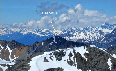


Located about halfway along the ~13-kilometer-long crest where well-trodden peaks such as Copper Mound, Mount McLeod, Seven O'clock Mountain, and Sun God Mountain are found is Mount Barbour. As with these others, Barbour is featured in Gunn's Scrambles in SWBC, benefits from relatively good access and can be accomplished in a very manageable day trip from Vancouver. The approach described in the guide follows a trail past Barbour's Draw/Valley that was once used by miners to graze horses as they traversed the range north-to-south. Culminating at a broad pass below Barbour's West Ridge, the 'draw is a very scenic place and well worth a visit just on its own. The scramble up the West Ridge is straight-forward and makes for a satisfying final ascent to a perch with impressive 360-degree views!

Barbour can be approached from the west via Tenquille Lake Trail or from the east via Tenquille Creek Trail. Having previously hiked to Tenquille Lake for both Tenquille Mountain and Goat Peak, I took the east approach for something different. I also brought a bike for the mostly flat ~5 kms between where the FSR is gated and the trailhead proper. Not sure what the purpose of this gate is as the road beyond is perfectly driveable by just about any type of vehicle, at least to the overgrown fork that continues up-valley to the trailhead. A sign near the gate does warn about grizzlies and some sort of seasonal closure, so travel here at your own peril. Reaching the road end, I stashed my bike and walked a short distance to a stream crossing with the trail just beyond. Pleasant forest hike from here some 2.7 kms to the junction with Tenquille Lake Trail. Turned left and headed up into Barbour's Draw. Up out of the forest in short order, entering an enchanting land of meadows and turquoise-hued lakelets. Leaving the main trail now, I continued straight ahead to reach a broad pass overlooking Lillooet River Valley far below. Turned left here and made my way up the lower west slopes of Barbour. Finally, I gained the West Ridge to avoid a steep rock face directly above and followed that easily up to the summit.

Great views despite some smoke obscuring the more distant peaks and glaciers. Noteworthy were Mount Sampson and the Railroad Group, Sun God Mountain, Lillooet River Valley and of course a bird's-eye view of the 'draw! Spent about :45 up top before heading back down. Back at the trailhead, I heard an unsettling rustling/crashing sound off in the bush adjacent to the old road as I was retrieving my bike. Something BIG was lurking nearby! On with the helmet, then took a deep breath before cranking hard and fast, making as much noise as I could! Please Mr. Grizz let me pass by unscathed! Back to the truck and cold beer without incident thank God, another bullet dodged and another peak down!

Click here to view.
home | email | copyright

All photos and text for sverdina.com are copyright © 2002-2024

It would be very much appreciated if you please ask before copying and/or re-publishing content from any part of these pages. To do so, please click here to send a message via feedback form.

Thank You.

©2024 sverdina.com |